Moses Lake fishing map is available as part of iBoating : USA Marine & Fishing App(now supported on multiple platforms including Android, iPhone/iPad, MacBook, and Windows(tablet and phone)/PC based chartplotter.).
With our Lake Maps App, you get all the great marine chart app features like fishing spots, along with Moses Lake depth map. The fishing maps app include HD lake depth contours, along with advanced features found in Fish Finder / Gps Chart Plotter systems, turning your device into a Depth Finder. The Moses Lake Navigation App provides advanced features of a Marine Chartplotter including adjusting water level offset and custom depth shading. Fishing spots and depth contours layers are available in most Lake maps. Lake navigation features include advanced instrumentation to gather wind speed direction, water temperature, water depth, and accurate GPS with AIS receivers(using NMEA over TCP/UDP). Autopilot support can be enabled during ‘Goto WayPoint’ and ‘Route Assistance’.
Now i-Boating supports Fishing Points in Moses Lake.
Have more questions about the Nautical Chart App? Ask us.
Fishing Info for Moses Lake
Moses Lake is a lake and reservoir along the course of Crab Creek, in Washington state, USA. Moses Lake is part of the Columbia River basin, as Crab Creek is a tributary of the Columbia River. Although originally a shallow natural lake, Moses Lake was dammed in the early 20th century for irrigation purposes. It then became part of the Columbia Basin Project, built and managed by the United States Bureau of Reclamation. Moses Lake receives water from Crab Creek, as well as from irrigated agricultural runoff. Its water used to flow out into Crab Creek, but now flows into Potholes Reservoir, a storage reservoir created by impounding Crab Creek at O'Sullivan Dam. Moses Lake is fairly complex in shape, with several arms, called "horns". These horns include Lewis Horn, Parker Horn, and Pelican Horn. There are several islands in Moses Lake, including Crest Island, Marsh Island, Gaileys Island, and Goat Island. Moses Lake was named after Chief Moses in the late 19th century. The city of Moses Lake was, in turn, named after the lake. The city of Moses Lake was first named Neppel, and not Moses Lake until 1938.
More on Wikipedia...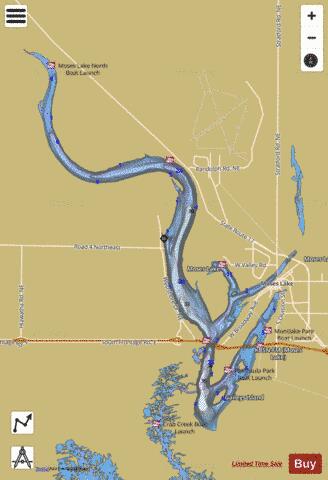
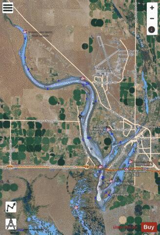
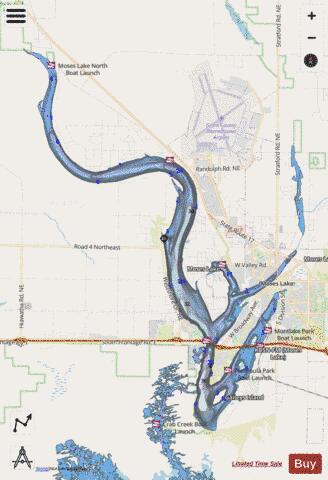
Moses Lake Fishing Map Stats | |
| Title | Moses Lake |
| Scale | 1:24000 |
| Counties | Grant |
| Nearby Cities | Moses Lake, McDonald, Wheeler, Ephrata, Soap Lake, Stratford, Ruff, Winchester, Wilson Creek, Othello |
| Area * | 6937.35 acres |
| Shoreline * | 82.62 miles |
| Min Longitude | -119.45 |
| Min Latitude | 47.06 |
| Max Longitude | -119.26 |
| Max Latitude | 47.24 |
| Edition Label 1 | |
| Edition Label 2 | |
| Edition Label 3 | |
| Id | US_WA_01506804 |
| Country | US |
| Projection | Mercator |
| * some Stats may include nearby/connecting waterbodies | |
|