Soap Lake fishing map is available as part of iBoating : USA Marine & Fishing App(now supported on multiple platforms including Android, iPhone/iPad, MacBook, and Windows(tablet and phone)/PC based chartplotter.).
With our Lake Maps App, you get all the great marine chart app features like fishing spots, along with Soap Lake depth map. The fishing maps app include HD lake depth contours, along with advanced features found in Fish Finder / Gps Chart Plotter systems, turning your device into a Depth Finder. The Soap Lake Navigation App provides advanced features of a Marine Chartplotter including adjusting water level offset and custom depth shading. Fishing spots and depth contours layers are available in most Lake maps. Lake navigation features include advanced instrumentation to gather wind speed direction, water temperature, water depth, and accurate GPS with AIS receivers(using NMEA over TCP/UDP). Autopilot support can be enabled during ‘Goto WayPoint’ and ‘Route Assistance’.
Now i-Boating supports Fishing Points in Soap Lake.
Have more questions about the Nautical Chart App? Ask us.
Fishing Info for Soap Lake
Soap Lake is a meromictic soda lake in the town of Soap Lake, Washington formed by the Missoula Floods at the foot of the Grand Coulee. The lake gets its name from the naturally occurring foam that gives its water a soapy appearance, and because the lake's mineral-rich waters have a slick, soapy feel. The lake is approximately 2 square miles (5.2 km2) in area and 70 feet (21 m) deep.
More on Wikipedia...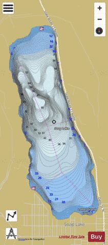
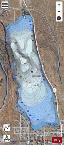
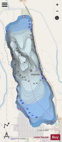
Soap Lake Fishing Map Stats | |
| Title | Soap Lake |
| Scale | 1:12000 |
| Counties | Grant |
| Nearby Cities | Soap Lake, Ephrata, Stratford, Winchester, Coulee City, Moses Lake, Farmer, Wilson Creek, Quincy, Wheeler |
| Area * | 843.97 acres |
| Shoreline * | 5.83 miles |
| Min Longitude | -119.51 |
| Min Latitude | 47.39 |
| Max Longitude | -119.48 |
| Max Latitude | 47.42 |
| Edition Label 1 | |
| Edition Label 2 | |
| Edition Label 3 | |
| Id | US_WA_01508485 |
| Country | US |
| Projection | Mercator |
| * some Stats may include nearby/connecting waterbodies | |
|