Lewis Lake fishing map is available as part of iBoating : USA Marine & Fishing App(now supported on multiple platforms including Android, iPhone/iPad, MacBook, and Windows(tablet and phone)/PC based chartplotter.).
With our Lake Maps App, you get all the great marine chart app features like fishing spots, along with Lewis Lake depth map. The fishing maps app include HD lake depth contours, along with advanced features found in Fish Finder / Gps Chart Plotter systems, turning your device into a Depth Finder. The Lewis Lake Navigation App provides advanced features of a Marine Chartplotter including adjusting water level offset and custom depth shading. Fishing spots and depth contours layers are available in most Lake maps. Lake navigation features include advanced instrumentation to gather wind speed direction, water temperature, water depth, and accurate GPS with AIS receivers(using NMEA over TCP/UDP). Autopilot support can be enabled during ‘Goto WayPoint’ and ‘Route Assistance’.
Have more questions about the Nautical Chart App? Ask us.
Fishing Info for Lewis Lake
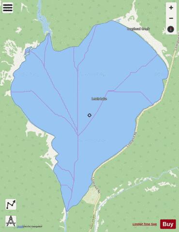
Lewis Lake is located in the U. S. state of Wyoming in the southern part of Yellowstone National Park, about 4 miles (6.4 km) southeast of Shoshone Lake, and approximately 10 miles (16 km) southwest of Yellowstone Lake. Lewis Lake and Shoshone Lake are both located a few miles northeast of the Pitchstone Plateau. The Lewis River is the lake's primary inflow, draining south from Shoshone Lake. The primary outflow of Lewis Lake is also the Lewis River, continuing south to join the Snake River near the southern boundary of Yellowstone National Park. A few small creeks also feed Lewis Lake. There are several hot springs emptying into the lake on its northwestern shore and two more hot springs at the lake's southern end where it empties into the Lewis River. A campground is located on the lake's southeast shore. Yellowstone National Park's South Entrance Road (which is also numbered as U.S. Route 287, U.S. Route 89, and U.S. Route 191), run along the east side of Lewis Lake. Like the river, Lewis Lake is named for Meriweather Lewis, commander of the Lewis and Clark Expedition Lewis lake holds brown, brook and lake trout and falls within the non-native trout tolerance area of the park. Anglers may keep up to five non-native trout per day but only one brown trout.
More on Wikipedia...Popular fish species in this lake include Brook trout and Lake trout.
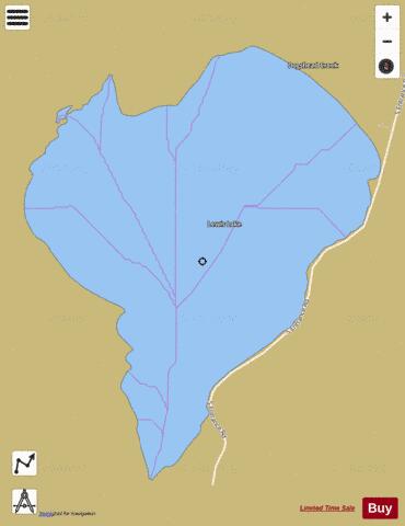

Lewis Lake Fishing Map Stats | |
| Title | Lewis Lake |
| Scale | 1:12000 |
| Counties | Teton |
| Nearby Cities | West Thumb, Lake, Moran, West Yellowstone, Moose, Big Springs, Grovont, Lamont, Kelly, Mammoth |
| Area * | 2775.05 acres |
| Shoreline * | 10.09 miles |
| Min Longitude | -110.65 |
| Min Latitude | 44.28 |
| Max Longitude | -110.60 |
| Max Latitude | 44.32 |
| Edition Label 1 | |
| Edition Label 2 | |
| Edition Label 3 | |
| Id | US_UB_WY_01590665 |
| Country | US |
| Projection | Mercator |
| * some Stats may include nearby/connecting waterbodies | |
|