Jenny Lake fishing map is available as part of iBoating : USA Marine & Fishing App(now supported on multiple platforms including Android, iPhone/iPad, MacBook, and Windows(tablet and phone)/PC based chartplotter.).
With our Lake Maps App, you get all the great marine chart app features like fishing spots, along with Jenny Lake depth map. The fishing maps app include HD lake depth contours, along with advanced features found in Fish Finder / Gps Chart Plotter systems, turning your device into a Depth Finder. The Jenny Lake Navigation App provides advanced features of a Marine Chartplotter including adjusting water level offset and custom depth shading. Fishing spots and depth contours layers are available in most Lake maps. Lake navigation features include advanced instrumentation to gather wind speed direction, water temperature, water depth, and accurate GPS with AIS receivers(using NMEA over TCP/UDP). Autopilot support can be enabled during ‘Goto WayPoint’ and ‘Route Assistance’.
Now i-Boating supports Fishing Points in Jenny Lake.
Have more questions about the Nautical Chart App? Ask us.
Fishing Info for Jenny Lake
Jenny Lake is located in Grand Teton National Park in the U.S. state of Wyoming. The lake was formed approximately 12,000 years ago by glaciers pushing rock debris which carved Cascade Canyon during the last glacial maximum, forming a terminal moraine which now impounds the lake. The lake is estimated to be 256 feet (78 m) deep and encompasses 1,191 acres (482 ha). Jenny Lake is considered to be a major focal point in Grand Teton National Park, with many hiking trails, scenic boat rides, and quick access to the major climbing routes onto the tallest peaks of the Teton Range. Jenny and Jackson Lakes are the only lakes in Grand Teton National Park where motorboats are permitted; both lakes have scenic tours available. A 2005 study of the water quality of the lakes in Grand Teton National Park indicated that all the lakes in the park were still considered pristine and that they had not been impacted by air or water pollution. Jenny Lake is a starting point for many day and overnight hiking trips. The 7.1-mile (11.4 km) Jenny Lake Trail loops around the lake and is considered to be relatively easy due to the small altitude gain of 700 feet (210 m). However, the altitude increases rapidly once Cascade Canyon is entered. Jenny Lake is named after a Shoshone Indian woman who married an Englishman, Richard "Beaver Dick" Leigh. Jenny, and their 6 children, died of Smallpox in 1876.
More on Wikipedia...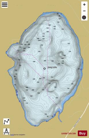
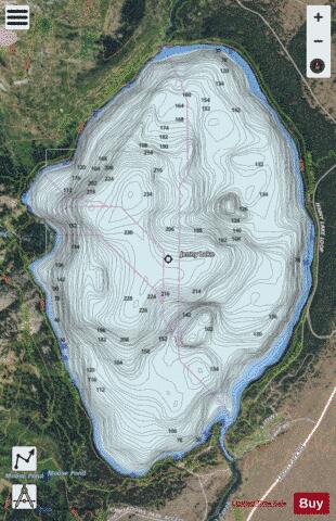
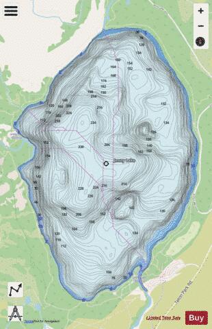
Jenny Lake Fishing Map Stats | |
| Title | Jenny Lake |
| Scale | 1:6000 |
| Counties | Teton |
| Nearby Cities | Moose, Grovont, Kelly, Teton Village, Moran, Jackson, Wilson, Alta, Driggs, Victor |
| Area * | 1206.78 acres |
| Shoreline * | 5.99 miles |
| Min Longitude | -110.74 |
| Min Latitude | 43.75 |
| Max Longitude | -110.72 |
| Max Latitude | 43.78 |
| Edition Label 1 | |
| Edition Label 2 | |
| Edition Label 3 | |
| Id | US_WY_01590084 |
| Country | US |
| Projection | Mercator |
| * some Stats may include nearby/connecting waterbodies | |
|