Lake Sutherland fishing map is available as part of iBoating : USA Marine & Fishing App(now supported on multiple platforms including Android, iPhone/iPad, MacBook, and Windows(tablet and phone)/PC based chartplotter.).
With our Lake Maps App, you get all the great marine chart app features like fishing spots, along with Lake Sutherland depth map. The fishing maps app include HD lake depth contours, along with advanced features found in Fish Finder / Gps Chart Plotter systems, turning your device into a Depth Finder. The Lake Sutherland Navigation App provides advanced features of a Marine Chartplotter including adjusting water level offset and custom depth shading. Fishing spots and depth contours layers are available in most Lake maps. Lake navigation features include advanced instrumentation to gather wind speed direction, water temperature, water depth, and accurate GPS with AIS receivers(using NMEA over TCP/UDP). Autopilot support can be enabled during ‘Goto WayPoint’ and ‘Route Assistance’.
Now i-Boating supports Fishing Points in Lake Sutherland.
Have more questions about the Nautical Chart App? Ask us.
Fishing Info for Lake Sutherland
Lake Sutherland is located on the Olympic Peninsula about 17 miles (27 km) west of Port Angeles, Washington. The lake is located just to the east of Lake Crescent. Lake Sutherland drains into Indian Creek, which is a tributary of the Elwha River. Lake Sutherland is named for the Canadian fur trapper John Sutherland who, with John Everett, explored the lake around 1865. Lake Sutherland and Indian Creek once sustained anadromous fish populations, but construction of the Elwha Dam in 1913 blocked access to the ocean, eliminating several salmon species from Indian Creek and landlocking others. The lake contains a population of kokanee sockeye salmon, which spawn in Lake Sutherland and until the removal of the Elwha Dam in 2012 migrated to Lake Aldwell. Lake Sutherland lies just outside Olympic National Park and is private land. The lake is surrounded by houses, many of which are vacation homes inhabited only seasonally. Boating and fishing on the lake are very popular. There is also a reservoir in San Diego County, Situated between Ramona and Julian, with the same name.
More on Wikipedia...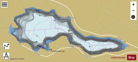
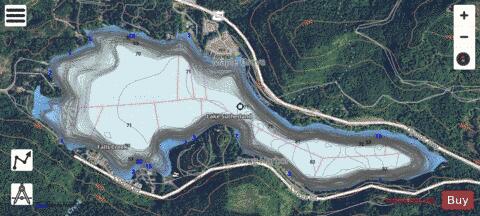
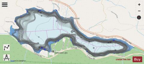
Lake Sutherland Fishing Map Stats | |
| Title | Lake Sutherland |
| Scale | 1:12000 |
| Counties | Clallam |
| Nearby Cities | Joyce, Port Angeles, Carlsborg, Sappho, Clallam Bay, Dungeness, Sequim, Sekiu, Quinault, Amanda Park |
| Area * | 366.14 acres |
| Shoreline * | 4.92 miles |
| Min Longitude | -123.72 |
| Min Latitude | 48.07 |
| Max Longitude | -123.69 |
| Max Latitude | 48.08 |
| Edition Label 1 | |
| Edition Label 2 | |
| Edition Label 3 | |
| Id | US_WA_01526808 |
| Country | US |
| Projection | Mercator |
| * some Stats may include nearby/connecting waterbodies | |
|