Summit Lake fishing map is available as part of iBoating : USA Marine & Fishing App(now supported on multiple platforms including Android, iPhone/iPad, MacBook, and Windows(tablet and phone)/PC based chartplotter.).
With our Lake Maps App, you get all the great marine chart app features like fishing spots, along with Summit Lake depth map. The fishing maps app include HD lake depth contours, along with advanced features found in Fish Finder / Gps Chart Plotter systems, turning your device into a Depth Finder. The Summit Lake Navigation App provides advanced features of a Marine Chartplotter including adjusting water level offset and custom depth shading. Fishing spots and depth contours layers are available in most Lake maps. Lake navigation features include advanced instrumentation to gather wind speed direction, water temperature, water depth, and accurate GPS with AIS receivers(using NMEA over TCP/UDP). Autopilot support can be enabled during ‘Goto WayPoint’ and ‘Route Assistance’.
Now i-Boating supports Fishing Points in Summit Lake.
Have more questions about the Nautical Chart App? Ask us.
Fishing Info for Summit Lake
Summit Lake is a freshwater lake located in the northwest corner in the southwestern county, Thurston County. The lake is about 7.6 mi (12.2 km) east of McCleary, Washington, 9.7 mi (15.6 km) west from the state capital of Olympia, and 9.8 mi (15.8 km) west-northwest of Tumwater, Washington. It is accessible through a Washington State Department of Fish and Wildlife owned boat launch at the southwestern side of the lake. Some of the fish found in this lake include rainbow trout, kokanee, largemouth bass, smallmouth bass, yellow perch, and coastal cutthroat. Summit Lake is a clean fresh water lake with a wide variety of fish. It is a popular lake to fish at in Thurston County and the South Puget Sound. Early variant names were "Prays Lake" and "Crooked Lake"; the present name was adopted c. 1900.
More on Wikipedia...Popular fish species in this lake include Largemouth bass, Rainbow trout, Smallmouth bass and Yellow perch.
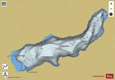

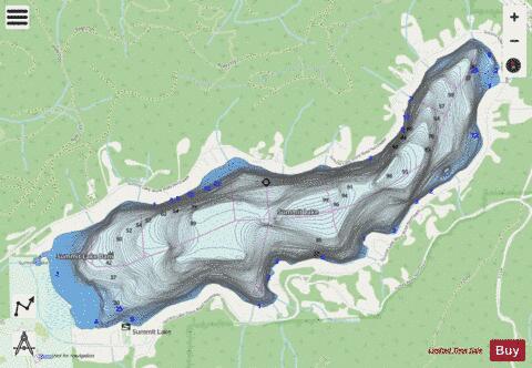
Summit Lake Fishing Map Stats | |
| Title | Summit Lake |
| Scale | 1:12000 |
| Counties | Thurston |
| Nearby Cities | McCleary, Shelton, Littlerock, Tumwater, Olympia, Boston Harbor, Porter, Malone, Rochester, Oakville |
| Area * | 511.88 acres |
| Shoreline * | 5.67 miles |
| Min Longitude | -123.12 |
| Min Latitude | 47.05 |
| Max Longitude | -123.08 |
| Max Latitude | 47.07 |
| Edition Label 1 | |
| Edition Label 2 | |
| Edition Label 3 | |
| Id | US_WA_01513483 |
| Country | US |
| Projection | Mercator |
| * some Stats may include nearby/connecting waterbodies | |
|