Ballston Lake fishing map is available as part of iBoating : USA Marine & Fishing App(now supported on multiple platforms including Android, iPhone/iPad, MacBook, and Windows(tablet and phone)/PC based chartplotter.).
With our Lake Maps App, you get all the great marine chart app features like fishing spots, along with Ballston Lake depth map. The fishing maps app include HD lake depth contours, along with advanced features found in Fish Finder / Gps Chart Plotter systems, turning your device into a Depth Finder. The Ballston Lake Navigation App provides advanced features of a Marine Chartplotter including adjusting water level offset and custom depth shading. Fishing spots and depth contours layers are available in most Lake maps. Lake navigation features include advanced instrumentation to gather wind speed direction, water temperature, water depth, and accurate GPS with AIS receivers(using NMEA over TCP/UDP). Autopilot support can be enabled during ‘Goto WayPoint’ and ‘Route Assistance’.
Now i-Boating supports Fishing Points in Ballston Lake.
Have more questions about the Nautical Chart App? Ask us.
Fishing Info for Ballston Lake
Ballston Lake is a lake that is located in the hamlet of Ballston Lake, New York in the town of Ballston. Fish species present in the lake are northern pike, smallmouth bass, largemouth bass, yellow perch, carp, pumpkinseed sunfish, and brown bullhead. The lake is meromictic, meaning its deeper waters never mix with the surface layer. In 2021, the cartop boat launch on Outlet Road was closed and the private boat launch located at Finnigan's On The Lake Restaurant was also closed, leaving no public boating access to the lake. In February 2022, the public fishing pier on the north end of the lake was closed due to damage sustained by ice over the winter.
More on Wikipedia...Popular fish species in this lake include Brown bullhead, Largemouth bass, Northern pike, Smallmouth bass and Yellow perch.
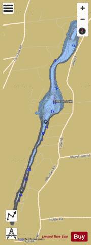
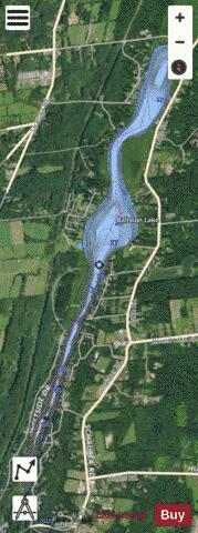
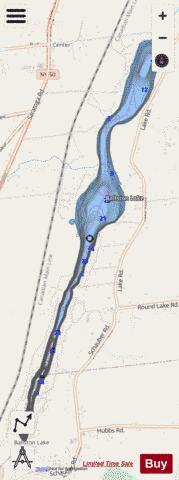
Ballston Lake Fishing Map Stats | |
| Title | Ballston Lake |
| Scale | 1:6000 |
| Counties | Saratoga |
| Nearby Cities | Ballston Spa, Malta, East Glenville, Round Lake, Milton, Charlton, Clifton Park, Schenectady, Scotia, Niskayuna |
| Area * | 263.59 acres |
| Shoreline * | 7.38 miles |
| Min Longitude | -73.87 |
| Min Latitude | 42.91 |
| Max Longitude | -73.85 |
| Max Latitude | 42.96 |
| Edition Label 1 | |
| Edition Label 2 | |
| Edition Label 3 | |
| Id | US_NY_1101_0036 |
| Country | US |
| Projection | Mercator |
| * some Stats may include nearby/connecting waterbodies | |
|