Upper Saranac Lake fishing map is available as part of iBoating : USA Marine & Fishing App(now supported on multiple platforms including Android, iPhone/iPad, MacBook, and Windows(tablet and phone)/PC based chartplotter.).
With our Lake Maps App, you get all the great marine chart app features like fishing spots, along with Upper Saranac Lake depth map. The fishing maps app include HD lake depth contours, along with advanced features found in Fish Finder / Gps Chart Plotter systems, turning your device into a Depth Finder. The Upper Saranac Lake Navigation App provides advanced features of a Marine Chartplotter including adjusting water level offset and custom depth shading. Fishing spots and depth contours layers are available in most Lake maps. Lake navigation features include advanced instrumentation to gather wind speed direction, water temperature, water depth, and accurate GPS with AIS receivers(using NMEA over TCP/UDP). Autopilot support can be enabled during ‘Goto WayPoint’ and ‘Route Assistance’.
Now i-Boating supports Fishing Points in Upper Saranac Lake.
Have more questions about the Nautical Chart App? Ask us.
Fishing Info for Upper Saranac Lake
Upper Saranac Lake is one of three connected lakes, part of the Saranac River, in the towns of Santa Clara and Harrietstown, near the village of Saranac Lake in the Adirondacks in northern New York. Upper Saranac Lake is the sixth largest lake in the Adirondacks. With Middle Saranac Lake and Lower Saranac Lake, a 17-mile (27 km) paddle with only one carry is possible. There are 20 primitive campsites accessible by boat available on a first-come basis. Upper Saranac Lake is also known as Sin-ha-lo-nen-ne-pus. The 37 miles of shoreline is 54 percent privately owned, and much of it is lined with "camps", ranging from true Great Camps to small weekend cottages. The lake, along with both Middle and Lower Saranac Lakes, is also part of the 740-mile Northern Forest Canoe Trail, which begins in Old Forge, NY and ends in Fort Kent, ME.
More on Wikipedia...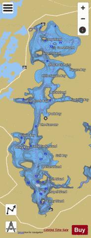
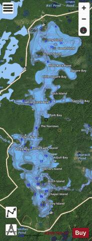
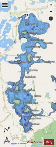
Upper Saranac Lake Fishing Map Stats | |
| Title | Upper Saranac Lake |
| Scale | 1:12000 |
| Counties | Franklin |
| Nearby Cities | Lake Clear, Paul Smiths, Tupper Lake, Harrietstown, Saranac Lake, Piercefield, Long Lake, Newcomb, Lake Placid, Tahawus |
| Area * | 4847.61 acres |
| Shoreline * | 47.09 miles |
| Min Longitude | -74.35 |
| Min Latitude | 44.23 |
| Max Longitude | -74.29 |
| Max Latitude | 44.35 |
| Edition Label 1 | |
| Edition Label 2 | |
| Edition Label 3 | |
| Id | US_NY_1003_0048 |
| Country | US |
| Projection | Mercator |
| * some Stats may include nearby/connecting waterbodies | |
|