Lake Quinsigamond fishing map is available as part of iBoating : USA Marine & Fishing App(now supported on multiple platforms including Android, iPhone/iPad, MacBook, and Windows(tablet and phone)/PC based chartplotter.).
With our Lake Maps App, you get all the great marine chart app features like fishing spots, along with Lake Quinsigamond depth map. The fishing maps app include HD lake depth contours, along with advanced features found in Fish Finder / Gps Chart Plotter systems, turning your device into a Depth Finder. The Lake Quinsigamond Navigation App provides advanced features of a Marine Chartplotter including adjusting water level offset and custom depth shading. Fishing spots and depth contours layers are available in most Lake maps. Lake navigation features include advanced instrumentation to gather wind speed direction, water temperature, water depth, and accurate GPS with AIS receivers(using NMEA over TCP/UDP). Autopilot support can be enabled during ‘Goto WayPoint’ and ‘Route Assistance’.
Now i-Boating supports Fishing Points in Lake Quinsigamond.
Have more questions about the Nautical Chart App? Ask us.
Fishing Info for Lake Quinsigamond
Lake Quinsigamond (also Long Pond) is a body of water situated between the city of Worcester and the town of Shrewsbury in Worcester County, Massachusetts, United States. It is 4 miles (6 km) long, between 50 and 85 feet (15 and 26 m) deep, and has a surface area of approximately 772 acres (3.1 km²). Lake Quinsigamond hosts 8 islands with the majority owned by private citizens. Two islands are connected to land via bridge. The largest island, Drake Island, is still state owned. Water from the lake empties into the Quinsigamond River in the Blackstone Valley.
More on Wikipedia...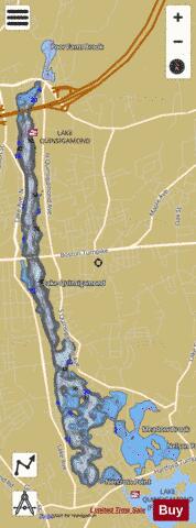
Lake Quinsigamond Fishing Map Stats | |
| Title | Lake Quinsigamond |
| Scale | 1:6000 |
| Counties | Worcester |
| Nearby Cities | Shrewsbury, Worcester, Millbury, Grafton, West Boylston, Sutton, Auburn, Northborough, Westborough, Holden |
| Area * | 592.91 acres |
| Shoreline * | 17.21 miles |
| Min Longitude | -71.76 |
| Min Latitude | 42.24 |
| Max Longitude | -71.73 |
| Max Latitude | 42.30 |
| Edition Label 1 | |
| Edition Label 2 | |
| Edition Label 3 | |
| Id | US_MA_malac_lake_quinsigamond |
| Country | US |
| Projection | Mercator |
| * some Stats may include nearby/connecting waterbodies | |
|