Lac des Allemands fishing map is available as part of iBoating : USA Marine & Fishing App(now supported on multiple platforms including Android, iPhone/iPad, MacBook, and Windows(tablet and phone)/PC based chartplotter.).
With our Lake Maps App, you get all the great marine chart app features like fishing spots, along with Lac des Allemands depth map. The fishing maps app include HD lake depth contours, along with advanced features found in Fish Finder / Gps Chart Plotter systems, turning your device into a Depth Finder. The Lac des Allemands Navigation App provides advanced features of a Marine Chartplotter including adjusting water level offset and custom depth shading. Fishing spots and depth contours layers are available in most Lake maps. Lake navigation features include advanced instrumentation to gather wind speed direction, water temperature, water depth, and accurate GPS with AIS receivers(using NMEA over TCP/UDP). Autopilot support can be enabled during ‘Goto WayPoint’ and ‘Route Assistance’.
Now i-Boating supports Fishing Points in Lac des Allemands.
Have more questions about the Nautical Chart App? Ask us.
Fishing Info for Lac des Allemands
Lac des Allemands is a 12,000-acre (4,900 ha) lake located about 25 miles (40 km) southwest of New Orleans, Louisiana, in Lafourche, St. Charles, and St. John the Baptist Parishes. The lake name is French for "Lake of the Germans", referring to the early settlers who inhabited that part of Louisiana. St. Charles Parish and St. John the Baptist Parish are part of a region called the German Coast. Lac des Allemands is a shallow lake, with a maximum depth of 10 feet (3.0 m) and an average depth of about 5 feet (1.5 m). It is mostly located at sea level and measures about 5.5 miles (8.9 km) long and 6.5 miles (10.5 km) wide. The lake is fed by bayous in the Barataria Basin including Grand Bayou and Bayou Chevreuil. Its waters flow southeast into , then into Lake Salvador and eventually the Gulf of Mexico. Lac des Allemands is surrounded by cypress swamp and the bayous and canals offer a habitat for catfish, bass, bream, crappie and panfish. Three species of catfish (flathead, channel, and blue) spawn in the lake from May through September. The community of Des Allemands is located southeast of the lake on Bayou des Allemands. In 1975, Governor Edwin Edwards declared Des Allemands the "Catfish Capital of the World" and the Louisiana legislature named it the "Catfish Capital of the Universe". Each July, Des Allemands hosts the .The name "Catfish Capital of the World" was challenged by another place that claimed the title, so Des Allemands was renamed to Catfish Capital of the Universe.
More on Wikipedia...Popular fish species in this lake include Crappie and Panfish.

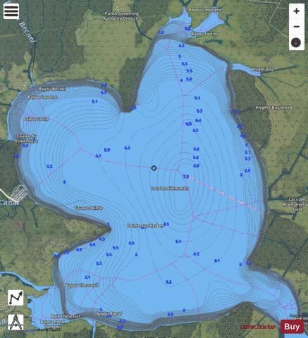
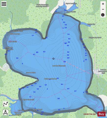
Lac des Allemands Fishing Map Stats | |
| Title | Lac des Allemands |
| Scale | 1:6000 |
| Counties | Lafourche, St. Charles, St. John the Baptist |
| Nearby Cities | Edgard, Killona, Des Allemands, Reserve, Kraemer, Montz, Paradis, Garyville, Taft, Wallace |
| Area * | 17541.36 acres |
| Shoreline * | 32.77 miles |
| Min Longitude | -90.63 |
| Min Latitude | 29.88 |
| Max Longitude | -90.52 |
| Max Latitude | 29.98 |
| Edition Label 1 | |
| Edition Label 2 | |
| Edition Label 3 | |
| Id | US_LM_CC_lac_des_allemands |
| Country | US |
| Projection | Mercator |
| * some Stats may include nearby/connecting waterbodies | |
|