West Monponsett Pond fishing map is available as part of iBoating : USA Marine & Fishing App(now supported on multiple platforms including Android, iPhone/iPad, MacBook, and Windows(tablet and phone)/PC based chartplotter.).
With our Lake Maps App, you get all the great marine chart app features like fishing spots, along with West Monponsett Pond depth map. The fishing maps app include HD lake depth contours, along with advanced features found in Fish Finder / Gps Chart Plotter systems, turning your device into a Depth Finder. The West Monponsett Pond Navigation App provides advanced features of a Marine Chartplotter including adjusting water level offset and custom depth shading. Fishing spots and depth contours layers are available in most Lake maps. Lake navigation features include advanced instrumentation to gather wind speed direction, water temperature, water depth, and accurate GPS with AIS receivers(using NMEA over TCP/UDP). Autopilot support can be enabled during ‘Goto WayPoint’ and ‘Route Assistance’.
Now i-Boating supports Fishing Points in West Monponsett Pond.
Have more questions about the Nautical Chart App? Ask us.
Fishing Info for West Monponsett Pond
Monponsett Pond, also called Monponsett Lake and the Twin Lakes, originally one lake is dissected by route 58 into a system of two ponds, West and East, mostly in Halifax, Massachusetts, with a small portion of West Monponsett Pond extending into Hanson. The western basin is 282 acres (1.14 km2), and the eastern basin is 246 acres (1.00 km2). The average depth of both ponds is seven feet and the maximum depth is 13 feet (4.0 m). The outflow is Stump Brook, a tributary of Poor Meadow Brook, in the northwestern part of West Monponsett Pond. The pond is part of the Taunton River Watershed. Occasionally during water shortages water from this pond is diverted into Silver Lake, the principal water supply for the City of Brockton. Route 58 bisects the two ponds. A paved boat launching ramp to West Monponsett Pond is on this highway north of White Island Road. White Island in the center of the pond is known to have been the fishing camp of Wamsutta, brother of Chief Metacomet (also known as King Philip). A culvert connecting the two ponds is nearby. Route 106 runs close to the southern shore of East Monponsett Pond, and Route 36 abuts the southeast corner of East Monponsett Pond, where there is a paved launching ramp. Access to West Monponsett Pond for larger boats can be found off of route 58, and for smaller boats there is an unpaved ramp off Lingan Street. Monponsett Pond Seaplane Base is located on this pond.
More on Wikipedia...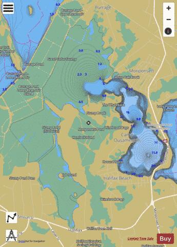
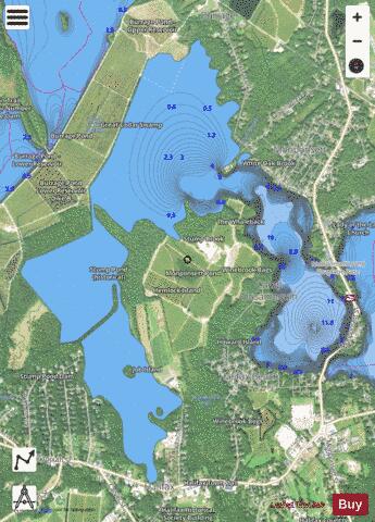
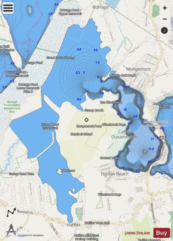
West Monponsett Pond Fishing Map Stats | |
| Title | West Monponsett Pond |
| Scale | 1:6000 |
| Counties | Plymouth |
| Nearby Cities | Halifax, Hanson, Plympton, Pembroke, East Bridgewater, Whitman, Hanover Center, North Pembroke, West Hanover, Hanover |
| Area * | 921.40 acres |
| Shoreline * | 13.07 miles |
| Min Longitude | -70.88 |
| Min Latitude | 41.99 |
| Max Longitude | -70.84 |
| Max Latitude | 42.03 |
| Edition Label 1 | |
| Edition Label 2 | |
| Edition Label 3 | |
| Id | US_CC_MA_west_monponsett_pond_jul21_ma |
| Country | US |
| Projection | Mercator |
| * some Stats may include nearby/connecting waterbodies | |
|