Halfway Pond fishing map is available as part of iBoating : USA Marine & Fishing App(now supported on multiple platforms including Android, iPhone/iPad, MacBook, and Windows(tablet and phone)/PC based chartplotter.).
With our Lake Maps App, you get all the great marine chart app features like fishing spots, along with Halfway Pond depth map. The fishing maps app include HD lake depth contours, along with advanced features found in Fish Finder / Gps Chart Plotter systems, turning your device into a Depth Finder. The Halfway Pond Navigation App provides advanced features of a Marine Chartplotter including adjusting water level offset and custom depth shading. Fishing spots and depth contours layers are available in most Lake maps. Lake navigation features include advanced instrumentation to gather wind speed direction, water temperature, water depth, and accurate GPS with AIS receivers(using NMEA over TCP/UDP). Autopilot support can be enabled during ‘Goto WayPoint’ and ‘Route Assistance’.
Now i-Boating supports Fishing Points in Halfway Pond.
Have more questions about the Nautical Chart App? Ask us.
Fishing Info for Halfway Pond
Halfway Pond a 232-acre (0.94 km2) warm water pond located in Plymouth, Massachusetts between Myles Standish State Forest and Long Pond, west of Round Pond, southwest of Gallows Pond, and north of Fawn Pond and White Island Pond. The average depth is nine feet and the maximum depth is 13 feet (4.0 m). The pond is fed by groundwater springs and drains into the Agawam River. Halfway Pond Island lies in the middle of the pond and is managed as a research natural area by The Nature Conservancy in Massachusetts. There are almost three miles (5 km) of shoreline. Access here is informal and can be located off of Mast Road, a portion of which abuts the western shoreline of the pond. Parking is limited to just two or three cars and boaters will have to stick with canoes and other car top craft. Substantial amounts of shoreline are open to fishing.
More on Wikipedia...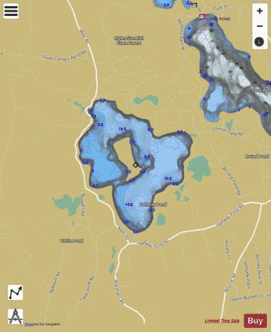
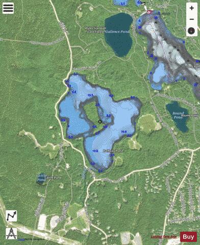
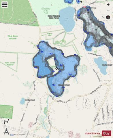
Halfway Pond Fishing Map Stats | |
| Title | Halfway Pond |
| Scale | 1:6000 |
| Counties | Plymouth |
| Nearby Cities | The Pinehills, White Island Shores, White Horse Beach, Buzzards Bay, Bourne, Plymouth, Onset, Sagamore, Monument Beach, North Plymouth |
| Area * | 214.99 acres |
| Shoreline * | 3.58 miles |
| Min Longitude | -70.62 |
| Min Latitude | 41.85 |
| Max Longitude | -70.61 |
| Max Latitude | 41.86 |
| Edition Label 1 | |
| Edition Label 2 | |
| Edition Label 3 | |
| Id | US_CC_MA_halfway_pond_jul21_ma |
| Country | US |
| Projection | Mercator |
| * some Stats may include nearby/connecting waterbodies | |
|