Heart Pond fishing map is available as part of iBoating : USA Marine & Fishing App(now supported on multiple platforms including Android, iPhone/iPad, MacBook, and Windows(tablet and phone)/PC based chartplotter.).
With our Lake Maps App, you get all the great marine chart app features like fishing spots, along with Heart Pond depth map. The fishing maps app include HD lake depth contours, along with advanced features found in Fish Finder / Gps Chart Plotter systems, turning your device into a Depth Finder. The Heart Pond Navigation App provides advanced features of a Marine Chartplotter including adjusting water level offset and custom depth shading. Fishing spots and depth contours layers are available in most Lake maps. Lake navigation features include advanced instrumentation to gather wind speed direction, water temperature, water depth, and accurate GPS with AIS receivers(using NMEA over TCP/UDP). Autopilot support can be enabled during ‘Goto WayPoint’ and ‘Route Assistance’.
Now i-Boating supports Fishing Points in Heart Pond.
Have more questions about the Nautical Chart App? Ask us.
Fishing Info for Heart Pond
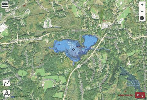
Heart Pond (also known as Hart Pond, Baptist Pond or Baptist lake) is a great pond located in the southwestern corner of Chelmsford, Massachusetts. The pond borders the town of Westford, Massachusetts. The pond has a surface area of 91 acres and a maximum depth of 20 ft. The pond is a and is a popular fishing spot in the town containing, Largemouth bass, Black Bullhead, Chain Pickerel, White and Yellow perch as well as Sunfish.
More on Wikipedia...Popular fish species in this lake include Largemouth bass and Yellow perch.
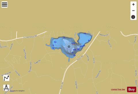
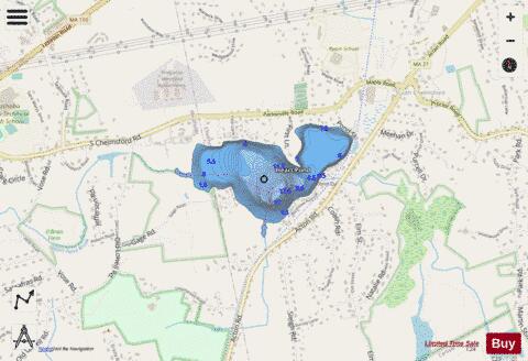
Heart Pond Fishing Map Stats | |
| Title | Heart Pond |
| Scale | 1:3000 |
| Counties | Middlesex |
| Nearby Cities | South Chelmsford, Chelmsford, Westford, Carlisle, Nabnasset, North Chelmsford, Graniteville, Littleton Common, Acton, Lowell |
| Area * | 93.87 acres |
| Shoreline * | 2.36 miles |
| Min Longitude | -71.40 |
| Min Latitude | 42.56 |
| Max Longitude | -71.38 |
| Max Latitude | 42.57 |
| Edition Label 1 | |
| Edition Label 2 | |
| Edition Label 3 | |
| Id | US_CC_MA_00611238 |
| Country | US |
| Projection | Mercator |
| * some Stats may include nearby/connecting waterbodies | |
|