Lake Dubay fishing map is available as part of iBoating : USA Marine & Fishing App(now supported on multiple platforms including Android, iPhone/iPad, MacBook, and Windows(tablet and phone)/PC based chartplotter.).
With our Lake Maps App, you get all the great marine chart app features like fishing spots, along with Lake Dubay depth map. The fishing maps app include HD lake depth contours, along with advanced features found in Fish Finder / Gps Chart Plotter systems, turning your device into a Depth Finder. The Lake Dubay Navigation App provides advanced features of a Marine Chartplotter including adjusting water level offset and custom depth shading. Fishing spots and depth contours layers are available in most Lake maps. Lake navigation features include advanced instrumentation to gather wind speed direction, water temperature, water depth, and accurate GPS with AIS receivers(using NMEA over TCP/UDP). Autopilot support can be enabled during ‘Goto WayPoint’ and ‘Route Assistance’.
Now i-Boating supports Fishing Points in Lake Dubay.
Have more questions about the Nautical Chart App? Ask us.
Fishing Info for Lake Dubay
Lake DuBay is a reservoir on the Wisconsin River in Marathon and Portage Counties in the U.S. state of Wisconsin. The lake covers an area of 6,700 acres (2,700 ha) and has a maximum depth of 30 feet (9.1 m). A dam on the lake is used to generate hydroelectric power. The community of Knowlton is located on the shore of the lake, as are 122 homes and three parks. Interstate 39 and U.S. Route 51 provide access to the lake, as do several county highways. While the lake is frozen in winter, it is used for ice racing by the "Winter Thunder Club".
More on Wikipedia...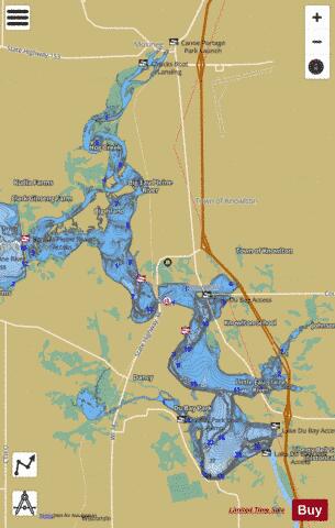
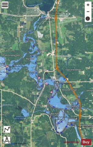
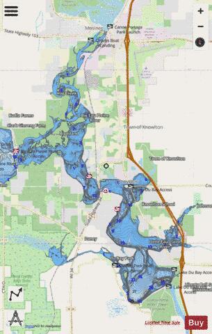
Lake Dubay Fishing Map Stats | |
| Title | Lake Dubay |
| Scale | 1:12000 |
| Counties | Marathon, Portage |
| Nearby Cities | Knowlton, Mosinee, Evergreen, Junction City, Rothschild, Milladore, Schofield, Stevens Point, Weston, Park Ridge |
| Area * | 5860.66 acres |
| Shoreline * | 145.40 miles |
| Min Longitude | -89.76 |
| Min Latitude | 44.66 |
| Max Longitude | -89.63 |
| Max Latitude | 44.79 |
| Edition Label 1 | |
| Edition Label 2 | |
| Edition Label 3 | |
| Id | US_AA_WI_lake_dubay_wi |
| Country | US |
| Projection | Mercator |
| * some Stats may include nearby/connecting waterbodies | |
|