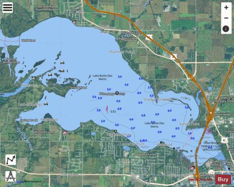
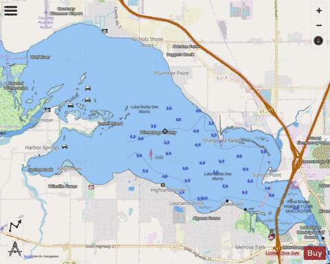
Lake Butte des Morts fishing map is available as part of iBoating : USA Marine & Fishing App(now supported on multiple platforms including Android, iPhone/iPad, MacBook, and Windows(tablet and phone)/PC based chartplotter.).
With our Lake Maps App, you get all the great marine chart app features like fishing spots, along with Lake Butte des Morts depth map. The fishing maps app include HD lake depth contours, along with advanced features found in Fish Finder / Gps Chart Plotter systems, turning your device into a Depth Finder. The Lake Butte des Morts Navigation App provides advanced features of a Marine Chartplotter including adjusting water level offset and custom depth shading. Fishing spots and depth contours layers are available in most Lake maps. Lake navigation features include advanced instrumentation to gather wind speed direction, water temperature, water depth, and accurate GPS with AIS receivers(using NMEA over TCP/UDP). Autopilot support can be enabled during ‘Goto WayPoint’ and ‘Route Assistance’.
Now i-Boating supports Fishing Points in Lake Butte des Morts.
Have more questions about the Nautical Chart App? Ask us.
Fishing Info for Lake Butte des Morts
Big Lake Butte des Morts (/ˌbjuːdəˈmɔːr/) is a shallow freshwater lake located in the U.S. state of Wisconsin, in Winnebago County. It is part of the Winnebago Pool (also known as the Winnebago System) of lakes in east central Wisconsin, along with Lake Winnebago, Lake Poygan, and Lake Winneconne. The lake is fed by the Fox River in the southwest and the Wolf River draining from Lake Winneconne in the northwest, and drains via the Fox River southeast into Lake Winnebago. The lake is part of the Butte des Morts region in Winnebago County, Wisconsin. This lake is not connected to Little Lake Butte des Morts, which is located to the north, downstream of Lake Winnebago, fed by the lower Fox River. The name "Butte des Morts" was given by French colonial settlers. It means "Mound of the Dead", in reference to a nearby prehistoric Native American burial mound. In the Menominee language this place is known as Paehkuahkīhsaeh which means "small mound".
More on Wikipedia...Popular fish species in this lake include Crappie, Largemouth bass, Round goby, Smallmouth bass, Walleye, White bass and Yellow perch.
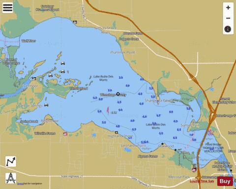
Lake Butte des Morts Fishing Map Stats | |
| Title | Lake Butte des Morts |
| Scale | 1:24000 |
| Counties | Winnebago |
| Nearby Cities | Butte des Morts, Winneconne, Oshkosh, Allenville, Omro, Winnebago, Winchester, Larsen, Waukau, Black Wolf |
| Area * | 8573.55 acres |
| Shoreline * | 51.78 miles |
| Min Longitude | -88.70 |
| Min Latitude | 44.03 |
| Max Longitude | -88.57 |
| Max Latitude | 44.10 |
| Edition Label 1 | |
| Edition Label 2 | |
| Edition Label 3 | |
| Id | US_AA_WI_lake_butte |
| Country | US |
| Projection | Mercator |
| * some Stats may include nearby/connecting waterbodies | |
|