Kangaroo Lake fishing map is available as part of iBoating : USA Marine & Fishing App(now supported on multiple platforms including Android, iPhone/iPad, MacBook, and Windows(tablet and phone)/PC based chartplotter.).
With our Lake Maps App, you get all the great marine chart app features like fishing spots, along with Kangaroo Lake depth map. The fishing maps app include HD lake depth contours, along with advanced features found in Fish Finder / Gps Chart Plotter systems, turning your device into a Depth Finder. The Kangaroo Lake Navigation App provides advanced features of a Marine Chartplotter including adjusting water level offset and custom depth shading. Fishing spots and depth contours layers are available in most Lake maps. Lake navigation features include advanced instrumentation to gather wind speed direction, water temperature, water depth, and accurate GPS with AIS receivers(using NMEA over TCP/UDP). Autopilot support can be enabled during ‘Goto WayPoint’ and ‘Route Assistance’.
Now i-Boating supports Fishing Points in Kangaroo Lake.
Have more questions about the Nautical Chart App? Ask us.
Fishing Info for Kangaroo Lake
Kangaroo Lake is the largest inland lake in Door County, Wisconsin, United States. It is located in the towns of Baileys Harbor and Jacksonport, and is the main feature of Kangaroo Lake State Natural Area. The lake, located a half mile from Lake Michigan, is fed by Piel Creek and surrounded by a lowland marsh. The bottom of the lake is lined with marl. Many types of fish can be found in the lake. The surrounding area is a tourist destination.
More on Wikipedia...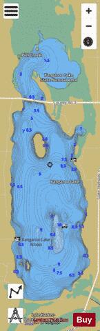
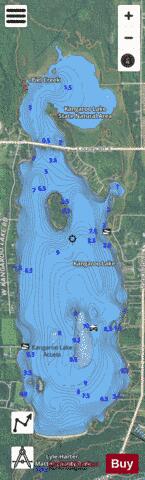
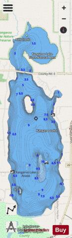
Kangaroo Lake Fishing Map Stats | |
| Title | Kangaroo Lake |
| Scale | 1:12000 |
| Counties | Door |
| Nearby Cities | Baileys Harbor, Jacksonport, Ephraim, Fish Creek, Whitefish Bay, Egg Harbor, Sister Bay, Institute, Carlsville, Ellison Bay |
| Area * | 1155.90 acres |
| Shoreline * | 10.92 miles |
| Min Longitude | -87.17 |
| Min Latitude | 45.02 |
| Max Longitude | -87.15 |
| Max Latitude | 45.06 |
| Edition Label 1 | |
| Edition Label 2 | |
| Edition Label 3 | |
| Id | US_AA_WI_kangaroo_lake_wi |
| Country | US |
| Projection | Mercator |
| * some Stats may include nearby/connecting waterbodies | |
|