Sacajawea Lake, Cowlitz Lake, County fishing map is available as part of iBoating : USA Marine & Fishing App(now supported on multiple platforms including Android, iPhone/iPad, MacBook, and Windows(tablet and phone)/PC based chartplotter.).
With our Lake Maps App, you get all the great marine chart app features like fishing spots, along with Sacajawea Lake, Cowlitz Lake, County depth map. The fishing maps app include HD lake depth contours, along with advanced features found in Fish Finder / Gps Chart Plotter systems, turning your device into a Depth Finder. The Sacajawea Lake, Cowlitz Lake, County Navigation App provides advanced features of a Marine Chartplotter including adjusting water level offset and custom depth shading. Fishing spots and depth contours layers are available in most Lake maps. Lake navigation features include advanced instrumentation to gather wind speed direction, water temperature, water depth, and accurate GPS with AIS receivers(using NMEA over TCP/UDP). Autopilot support can be enabled during ‘Goto WayPoint’ and ‘Route Assistance’.
Now i-Boating supports Fishing Points in Sacajawea Lake, Cowlitz Lake, County.
Have more questions about the Nautical Chart App? Ask us.
Fishing Info for Sacajawea Lake, Cowlitz Lake, County
Lake Sacajawea is a man-made lake in Longview, Washington. It is named after the Shoshone woman named Sacajawea who guided Meriwether Lewis and William Clark during their expedition to the Pacific Ocean. The lake is made up of four sections, each separated by a bridged road. Several small parks are part of the larger Lake Sacajawea Park. Lake Sacajawea Park is a 67-acre (27 ha) park in the middle of the city. The lake's water is pumped into the north end from the Cowlitz River and flows to the south end where it exits into the Columbia River.
More on Wikipedia...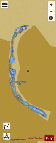

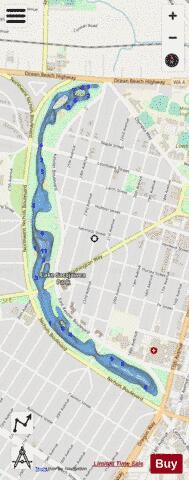
Sacajawea Lake, Cowlitz Lake, County Fishing Map Stats | |
| Title | Sacajawea Lake, Cowlitz Lake, County |
| Scale | 1:6000 |
| Counties | Cowlitz |
| Nearby Cities | Longview, Kelso, Rainier, Lexington, Ostrander, Prescott, Carrolls, Castle Rock, Kalama, Silver Lake |
| Area * | 45.45 acres |
| Shoreline * | 4.36 miles |
| Min Longitude | -122.95 |
| Min Latitude | 46.13 |
| Max Longitude | -122.94 |
| Max Latitude | 46.15 |
| Edition Label 1 | |
| Edition Label 2 | |
| Edition Label 3 | |
| Id | US_AA_WA_sacajawea_lake_cowlitz_lake |
| Country | US |
| Projection | Mercator |
| * some Stats may include nearby/connecting waterbodies | |
|