Rimrock Lake fishing map is available as part of iBoating : USA Marine & Fishing App(now supported on multiple platforms including Android, iPhone/iPad, MacBook, and Windows(tablet and phone)/PC based chartplotter.).
With our Lake Maps App, you get all the great marine chart app features like fishing spots, along with Rimrock Lake depth map. The fishing maps app include HD lake depth contours, along with advanced features found in Fish Finder / Gps Chart Plotter systems, turning your device into a Depth Finder. The Rimrock Lake Navigation App provides advanced features of a Marine Chartplotter including adjusting water level offset and custom depth shading. Fishing spots and depth contours layers are available in most Lake maps. Lake navigation features include advanced instrumentation to gather wind speed direction, water temperature, water depth, and accurate GPS with AIS receivers(using NMEA over TCP/UDP). Autopilot support can be enabled during ‘Goto WayPoint’ and ‘Route Assistance’.
Now i-Boating supports Fishing Points in Rimrock Lake.
Have more questions about the Nautical Chart App? Ask us.
Fishing Info for Rimrock Lake
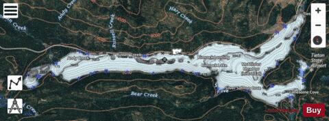
Rimrock Lake is a lake along the course of the Tieton River, in Yakima County, Washington state, US. The lake is used as a storage reservoir for the Yakima Project, an irrigation project run by the United States Bureau of Reclamation. An impoundment of the Tieton River, Rimrock Lake's capacity and discharge is controlled by Tieton Dam, a 319-foot (97 m) high structure built in 1925. Rimrock Lake's active capacity is 198,000 acre-feet (244,000,000 m3). Upstream from the lake, the Tieton River is impounded by Clear Creek Dam, another element of the Yakima Project. About 8 miles (13 km) downstream from Rimrock Lake the Tieton River is tapped by the Tieton Diversion Dam, supplying water to the Tieton Main Canal. The canal supplies irrigation water to the Tieton Division of the Yakima Project, with excess and agricultural runoff draining into Ahtanum Creek, west of Yakima. Near the lakes are the communities of Rimrock and Silver Beach.
More on Wikipedia...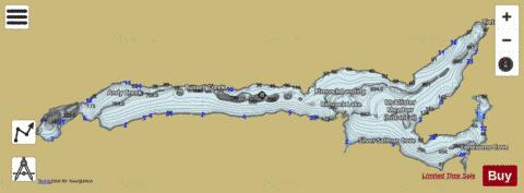
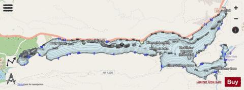
Rimrock Lake Fishing Map Stats | |
| Title | Rimrock Lake |
| Scale | 1:24000 |
| Counties | Yakima |
| Nearby Cities | Nile, Goose Prairie, Tampico, Cliffdell, Tieton, Packwood, Cowiche, Naches, White Swan, Eschbach |
| Area * | 2565.51 acres |
| Shoreline * | 22.86 miles |
| Min Longitude | -121.26 |
| Min Latitude | 46.63 |
| Max Longitude | -121.12 |
| Max Latitude | 46.66 |
| Edition Label 1 | |
| Edition Label 2 | |
| Edition Label 3 | |
| Id | US_AA_WA_rimrock_lake_wa |
| Country | US |
| Projection | Mercator |
| * some Stats may include nearby/connecting waterbodies | |
|