Lamoka Lake fishing map is available as part of iBoating : USA Marine & Fishing App(now supported on multiple platforms including Android, iPhone/iPad, MacBook, and Windows(tablet and phone)/PC based chartplotter.).
With our Lake Maps App, you get all the great marine chart app features like fishing spots, along with Lamoka Lake depth map. The fishing maps app include HD lake depth contours, along with advanced features found in Fish Finder / Gps Chart Plotter systems, turning your device into a Depth Finder. The Lamoka Lake Navigation App provides advanced features of a Marine Chartplotter including adjusting water level offset and custom depth shading. Fishing spots and depth contours layers are available in most Lake maps. Lake navigation features include advanced instrumentation to gather wind speed direction, water temperature, water depth, and accurate GPS with AIS receivers(using NMEA over TCP/UDP). Autopilot support can be enabled during ‘Goto WayPoint’ and ‘Route Assistance’.
Now i-Boating supports Fishing Points in Lamoka Lake.
Have more questions about the Nautical Chart App? Ask us.
Fishing Info for Lamoka Lake
Lamoka Lake, previously known as Mud Lake, is a small crescent-shaped lake in the western part of New York state. The lake is located at the border of Schuyler County and Steuben County. Most of the lake is in Schuyler County with only a small part, called "Mill Pond," at the southwest corner in Steuben County. North of Lamoka Lake is another lake called Waneta Lake, previously known as "Little Lake", which is linked to Lamoka Lake by a short channel. Both Lamoka Lake and Waneta Lake are east of Keuka Lake, one of the Finger Lakes, however they are not part of the Finger Lakes drainage system. While the Finger Lakes drain north into the St. Lawrence River system, Lamoka and Waneta Lakes drain south into Mill Pond, then Mud Creek, and then to the Cohocton River in the Susquehanna River system. The area is the location of a significant archeological site, the Lamoka site, which, according to the National Park Service, "provided the first clear evidence of an Archaic hunting and gathering culture in the Northeastern United States (c.3500 BC)". The site was designated a National Historic Landmark in 1961.
More on Wikipedia...Popular fish species in this lake include Black crappie, Brown bullhead, Largemouth bass, Panfish, Rock bass, Smallmouth bass and Yellow perch.
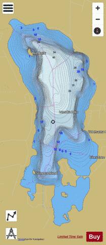
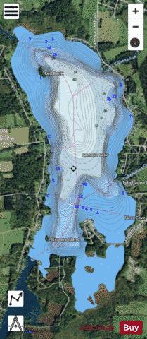
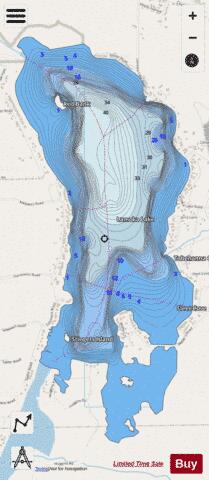
Lamoka Lake Fishing Map Stats | |
| Title | Lamoka Lake |
| Scale | 1:12000 |
| Counties | Schuyler |
| Nearby Cities | Tyrone, Bradford, Wayne, Keuka, Urbana, Barrington, Pulteney, Hammondsport, Dundee, Hornby |
| Area * | 644.24 acres |
| Shoreline * | 8.51 miles |
| Min Longitude | -77.09 |
| Min Latitude | 42.39 |
| Max Longitude | -77.07 |
| Max Latitude | 42.42 |
| Edition Label 1 | |
| Edition Label 2 | |
| Edition Label 3 | |
| Id | US_AA_NY_lamoka_lake_ny |
| Country | US |
| Projection | Mercator |
| * some Stats may include nearby/connecting waterbodies | |
|