Deer Lake fishing map is available as part of iBoating : USA Marine & Fishing App(now supported on multiple platforms including Android, iPhone/iPad, MacBook, and Windows(tablet and phone)/PC based chartplotter.).
With our Lake Maps App, you get all the great marine chart app features like fishing spots, along with Deer Lake depth map. The fishing maps app include HD lake depth contours, along with advanced features found in Fish Finder / Gps Chart Plotter systems, turning your device into a Depth Finder. The Deer Lake Navigation App provides advanced features of a Marine Chartplotter including adjusting water level offset and custom depth shading. Fishing spots and depth contours layers are available in most Lake maps. Lake navigation features include advanced instrumentation to gather wind speed direction, water temperature, water depth, and accurate GPS with AIS receivers(using NMEA over TCP/UDP). Autopilot support can be enabled during ‘Goto WayPoint’ and ‘Route Assistance’.
Now i-Boating supports Fishing Points in Deer Lake.
Have more questions about the Nautical Chart App? Ask us.
Fishing Info for Deer Lake
Deer Lake is a lake in the U.S. state of Michigan, located north of the city of Ishpeming. In the 1980, the lake was identified by the US and Canadian governments as one of 43 Areas of Concern (AOC) in the Great Lakes region. High levels of mercury had been detected in the lake and efforts have been made to reduce the amount of mercury going into the lake. As a result of contamination, Deer Lake was designated as a catch and release site, as fish caught in the lake were unsafe for consumption.In late 2014, the lake was delisted as an AOC, one of the first two lakes to be delisted in the state and one of only three AOCs to achieve the status. According to the EPA, the restrictions on fishing were removed as well.
More on Wikipedia...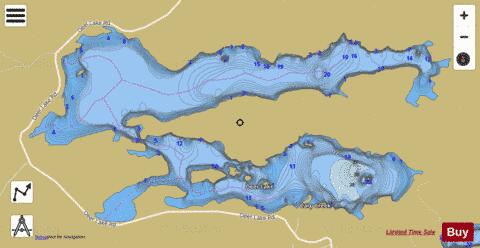
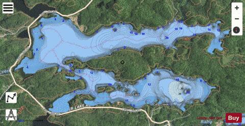
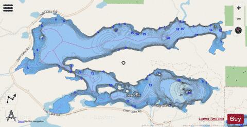
Deer Lake Fishing Map Stats | |
| Title | Deer Lake |
| Scale | 1:12000 |
| Includes Data from Fish Atlas | Yes |
| Counties | Marquette |
| Nearby Cities | Ishpeming, West Ishpeming, Negaunee, National Mine, Palmer, Trowbridge Park, Champion, Marquette, Big Bay, Republic |
| Area * | 918.74 acres |
| Shoreline * | 16.99 miles |
| Min Longitude | -87.71 |
| Min Latitude | 46.52 |
| Max Longitude | -87.65 |
| Max Latitude | 46.53 |
| Edition Label 1 | |
| Edition Label 2 | |
| Edition Label 3 | |
| Id | US_AA_MI_deer_lake_basin_mi |
| Country | US |
| Projection | Mercator |
| * some Stats may include nearby/connecting waterbodies | |
|