Lake Cochichewick fishing map is available as part of iBoating : USA Marine & Fishing App(now supported on multiple platforms including Android, iPhone/iPad, MacBook, and Windows(tablet and phone)/PC based chartplotter.).
With our Lake Maps App, you get all the great marine chart app features like fishing spots, along with Lake Cochichewick depth map. The fishing maps app include HD lake depth contours, along with advanced features found in Fish Finder / Gps Chart Plotter systems, turning your device into a Depth Finder. The Lake Cochichewick Navigation App provides advanced features of a Marine Chartplotter including adjusting water level offset and custom depth shading. Fishing spots and depth contours layers are available in most Lake maps. Lake navigation features include advanced instrumentation to gather wind speed direction, water temperature, water depth, and accurate GPS with AIS receivers(using NMEA over TCP/UDP). Autopilot support can be enabled during ‘Goto WayPoint’ and ‘Route Assistance’.
Now i-Boating supports Fishing Points in Lake Cochichewick.
Have more questions about the Nautical Chart App? Ask us.
Fishing Info for Lake Cochichewick
Lake Cochichewick is a lake in North Andover, Massachusetts that collects water from Weir Hill and other local uplands. Its overflow drains into the Cochichewick River, which joins the Merrimack. Brooks School, a private co-educational prep school, is located on the shores of the lake.
More on Wikipedia...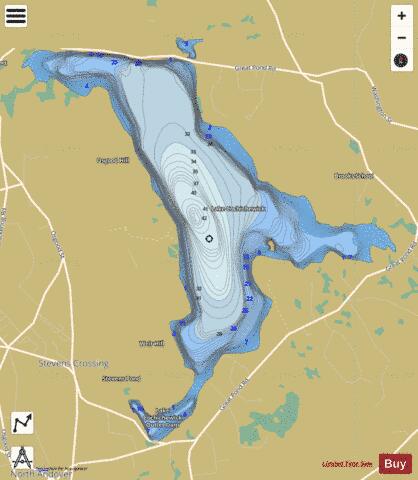
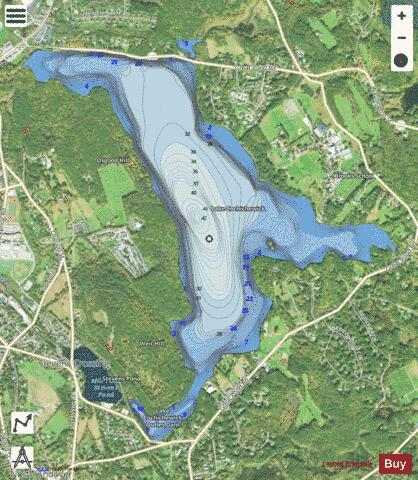
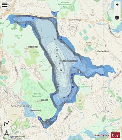
Lake Cochichewick Fishing Map Stats | |
| Title | Lake Cochichewick |
| Scale | 1:6000 |
| Counties | Essex |
| Nearby Cities | West Boxford, North Andover, Shawsheen Village, Andover, Lawrence, Haverhill, Methuen, Groveland, Ballardvale, Boxford |
| Area * | 578.89 acres |
| Shoreline * | 8.21 miles |
| Min Longitude | -71.12 |
| Min Latitude | 42.69 |
| Max Longitude | -71.08 |
| Max Latitude | 42.72 |
| Edition Label 1 | |
| Edition Label 2 | |
| Edition Label 3 | |
| Id | US_AA_MA_lake_cochichewick__ma |
| Country | US |
| Projection | Mercator |
| * some Stats may include nearby/connecting waterbodies | |
|