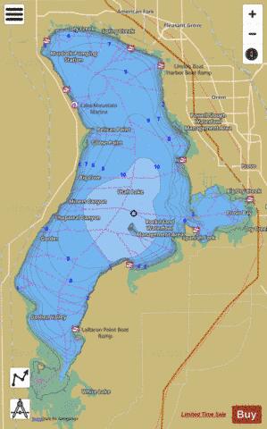
Utah Lake fishing map is available as part of iBoating : USA Marine & Fishing App(now supported on multiple platforms including Android, iPhone/iPad, MacBook, and Windows(tablet and phone)/PC based chartplotter.).
With our Lake Maps App, you get all the great marine chart app features like fishing spots, along with Utah Lake depth map. The fishing maps app include HD lake depth contours, along with advanced features found in Fish Finder / Gps Chart Plotter systems, turning your device into a Depth Finder. The Utah Lake Navigation App provides advanced features of a Marine Chartplotter including adjusting water level offset and custom depth shading. Fishing spots and depth contours layers are available in most Lake maps. Lake navigation features include advanced instrumentation to gather wind speed direction, water temperature, water depth, and accurate GPS with AIS receivers(using NMEA over TCP/UDP). Autopilot support can be enabled during ‘Goto WayPoint’ and ‘Route Assistance’.
Now i-Boating supports Fishing Points in Utah Lake.
Have more questions about the Nautical Chart App? Ask us.
Fishing Info for Utah Lake
Utah Lake is a shallow freshwater lake in the center of Utah County, Utah, United States. It lies in Utah Valley, surrounded by the Provo-Orem metropolitan area. The lake's only river outlet, the Jordan River, is a tributary of the Great Salt Lake. Evaporation accounts for 42% of the lake's outflow, which leaves the lake slightly saline. The elevation of the lake is at 4,489 feet (1,368 m) above sea level. If the lake's water level rises above that, the pumps and gates on the Jordan River are left open. Recently the lake has been at a lower level because of a drought. The first European to see Utah Lake was Father Silvestre Vélez de Escalante in 1776. He stayed with the Timpanogots band of Ute Tribe for three days. The Timpanogots were later integrated with the Mormon settlers or expelled from the area between the 1850s and 1870s. The fish of the lake were overharvested by the settlers and subsequently restocked with non-native species. Although thirteen species of fish were native to the lake, only the Utah sucker and the critically endangered June sucker remain. The dominant species in the lake is the common carp, introduced in 1883 as an alternative to the overharvested native fish. The carp is now estimated at 90% of the biomass of the lake and contributes to a decline in native fish populations by severely altering the ecosystem. Pollution has also caused problems with the lake's ecosystem. Raw sewage was dumped into the lake as late as 1967. Pollution problems still remain; the lake's phosphorus and mineral salt levels are in violation of the Clean Water Act. In recent years, the lake has been prone to harmful algal blooms or HABs. Utah Lake is managed cooperatively by the Utah Division of Forestry, Fire & State Lands and the Utah Lake Commission. The Division manages public use and issues a permit for commercial users of the lakebed and shoreline while the Commission facilitates development. The lakebed and surrounding shoreline are made up of State Sovereign Lands. Utah Lake is one of three lakes in the state that were deemed "navigable" at statehood and granted to the State of Utah. Sovereign lands are managed under the public trust doctrine. The Utah State Legislature has designated the Division of Forestry, Fire & State Lands as the executive authority for the management of sovereign lands and the state's mineral estates on lands other than school and institutional trust lands. Sovereign lands are defined by the Utah State Legislature as "those lands lying below the ordinary high water mark of navigable bodies of water at the date of statehood and owned by the state by virtue of its sovereignty." The Commission was created by State statute in Utah's 2007 General Legislative Session, House Concurrent Resolution 1, under the authority of the Interlocal Cooperation Act. The Commission is funded and empowered by 17 area governments, including; Utah County and its municipalities, the Central Utah Water Conservancy District, and three state agencies. Founded in 2007, the Commission seeks to promote multiple public uses of the lake, facilitate orderly planning and development in and around the lake, and enable individual Commission members to govern their own areas.
More on Wikipedia...Popular fish species in this lake include Black bullhead, Black crappie, Common carp, Fathead minnow, Golden shiner, Goldfish, Least chub, Longnose dace, Mottled sculpin, Mountain sucker, Utah Lake sculpin, Utah chub, Utah sucker, Walleye, White bass and Yellow perch.
Utah Lake Fishing Map Stats | |
| Title | Utah Lake |
| Scale | 1:12000 |
| Counties | Utah |
| Nearby Cities | Saratoga Springs, Vineyard, Palmyra, Provo, Lehi, American Fork, Lake Shore, Pleasant Grove, Lindon, Orem |
| Area * | 91157.28 acres |
| Shoreline * | 110.65 miles |
| Min Longitude | -111.94 |
| Min Latitude | 40.02 |
| Max Longitude | -111.65 |
| Max Latitude | 40.36 |
| Edition Label 1 | |
| Edition Label 2 | |
| Edition Label 3 | |
| Id | US_UT_01446894 |
| Country | US |
| Projection | Mercator |
| * some Stats may include nearby/connecting waterbodies | |
|


