Warm Springs Reservoir fishing map is available as part of iBoating : USA Marine & Fishing App(now supported on multiple platforms including Android, iPhone/iPad, MacBook, and Windows(tablet and phone)/PC based chartplotter.).
With our Lake Maps App, you get all the great marine chart app features like fishing spots, along with Warm Springs Reservoir depth map. The fishing maps app include HD lake depth contours, along with advanced features found in Fish Finder / Gps Chart Plotter systems, turning your device into a Depth Finder. The Warm Springs Reservoir Navigation App provides advanced features of a Marine Chartplotter including adjusting water level offset and custom depth shading. Fishing spots and depth contours layers are available in most Lake maps. Lake navigation features include advanced instrumentation to gather wind speed direction, water temperature, water depth, and accurate GPS with AIS receivers(using NMEA over TCP/UDP). Autopilot support can be enabled during ‘Goto WayPoint’ and ‘Route Assistance’.
Now i-Boating supports Fishing Points in Warm Springs Reservoir.
Have more questions about the Nautical Chart App? Ask us.
Fishing Info for Warm Springs Reservoir
Warm Springs Reservoir is a reservoir on the boundary between Harney and Malheur counties in the U.S. state of Oregon. It is located 13 miles (21 km) southwest of Juntura at an elevation of 3,406 feet (1,038 m). The lake's primary inflow and outflow are both the Malheur River. The 106-foot (32.3 m) tall and 469-foot (143 m) long thin-arch concrete Warm Springs Dam was built from 1918 to 1919 by the Warm Springs Irrigation District, and was later modified in 1930 and 1939 with the help of the United States Bureau of Reclamation.It was constructed from 19,500 cubic yards (14,900 m3) of material on top of a series of olivine basalt lava flows. The resultant 8.5-by-1.3-mile (14 by 2.1 km) reservoir has a maximum area of 4,194 acres (1,697 ha), a maximum volume of 169,714 acre-feet (209,339 dam3), and a maximum depth of 140 feet (42.7 m). It has a shore length of about 34.5 miles (55.5 km) and a residence time of about 2.2 years. Warm Springs Reservoir's watershed covers approximately 1,059.5 square miles (2,744.1 km2) of eastern Oregon. It receives an average precipitation of 17.5 inches (444 mm). As of the 2000 Census, there were 157 people living within the watershed's boundaries. The predominant wildlife in the region is mule deer and various waterfowl. Bass, bluegill, and rainbow trout are the main fish found in the reservoir.The reservoir is classified as eutrophic, with a transparency of about 3.3 feet (1.0 m).
More on Wikipedia...Popular fish species in this lake include Rainbow trout.
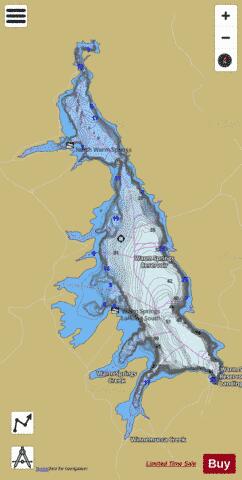
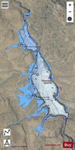
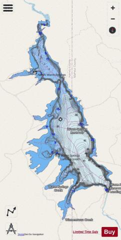
Warm Springs Reservoir Fishing Map Stats | |
| Title | Warm Springs Reservoir |
| Scale | 1:12000 |
| Counties | Harney, Malheur |
| Nearby Cities | Riverside, Juntura, Beulah, Crane, Princeton, Harney, Lawen, Westfall, Harper, Ironside |
| Area * | 4138.78 acres |
| Shoreline * | 32.29 miles |
| Min Longitude | -118.27 |
| Min Latitude | 43.57 |
| Max Longitude | -118.21 |
| Max Latitude | 43.67 |
| Edition Label 1 | |
| Edition Label 2 | |
| Edition Label 3 | |
| Id | US_UB_OR_warm_springs_reservoir |
| Country | US |
| Projection | Mercator |
| * some Stats may include nearby/connecting waterbodies | |
|