Lake Arrowhead Reservoir fishing map is available as part of iBoating : USA Marine & Fishing App(now supported on multiple platforms including Android, iPhone/iPad, MacBook, and Windows(tablet and phone)/PC based chartplotter.).
With our Lake Maps App, you get all the great marine chart app features like fishing spots, along with Lake Arrowhead Reservoir depth map. The fishing maps app include HD lake depth contours, along with advanced features found in Fish Finder / Gps Chart Plotter systems, turning your device into a Depth Finder. The Lake Arrowhead Reservoir Navigation App provides advanced features of a Marine Chartplotter including adjusting water level offset and custom depth shading. Fishing spots and depth contours layers are available in most Lake maps. Lake navigation features include advanced instrumentation to gather wind speed direction, water temperature, water depth, and accurate GPS with AIS receivers(using NMEA over TCP/UDP). Autopilot support can be enabled during ‘Goto WayPoint’ and ‘Route Assistance’.
Now i-Boating supports Fishing Points in Lake Arrowhead Reservoir.
Have more questions about the Nautical Chart App? Ask us.
Fishing Info for Lake Arrowhead Reservoir
Lake Arrowhead is an artificial lake located in the San Bernardino Mountains on Little Bear Creek, a tributary of Deep Creek and the Mojave River. It has a surface area of approximately 780 acres (320 ha) and a capacity of 48,000 acre⋅ft (59,000 dam3). It is surrounded by the unincorporated community of Lake Arrowhead in San Bernardino County, California. The lake was originally intended to serve as part of a major waterworks project to provide irrigation water to the San Bernardino Valley, and construction of the Lake Arrowhead Dam began toward that end in 1904. However, the original project was halted due to litigation over water supplies to land owners on the desert side of the mountains. Construction of the dam was completed in 1922 by the Arrowhead Lake Company, a Los Angeles syndicate, as part of a plan to develop the area into a resort. Use of the lake is currently controlled by the Arrowhead Lake Association, which maintains the lake for the recreational use of its members. Only Lake Arrowhead residents with lake rights may access the water. The Lake Arrowhead Community Services District withdraws water from the lake for treatment and distribution to local residents for potable use.
More on Wikipedia...
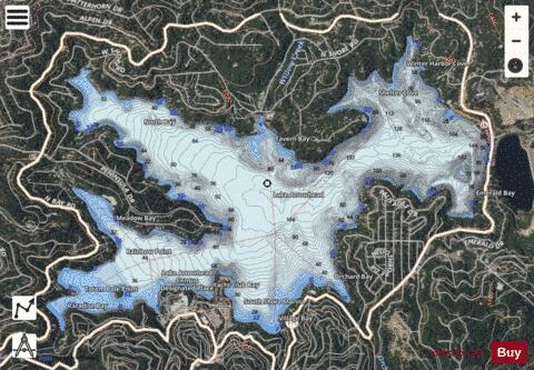
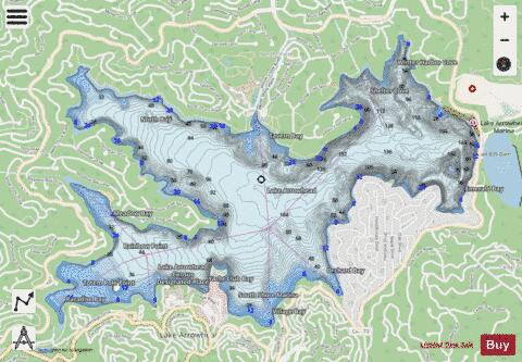
Lake Arrowhead Reservoir Fishing Map Stats | |
| Title | Lake Arrowhead Reservoir |
| Sailing Clubs in this Chart region | |
| Lake Arrowhead Yacht Club | |
| Scale | 1:6000 |
| Counties | San Bernardino |
| Nearby Cities | Lake Arrowhead, Cedar Glen, Blue Jay, Skyforest, Rimforest, Twin Peaks, Arrowhead Highlands, Smiley Park, Running Springs, Crestline |
| Area * | 736.20 acres |
| Shoreline * | 11.27 miles |
| Min Longitude | -117.20 |
| Min Latitude | 34.25 |
| Max Longitude | -117.17 |
| Max Latitude | 34.27 |
| Edition Label 1 | |
| Edition Label 2 | |
| Edition Label 3 | |
| Id | US_UB_CA_lake_arrowhead_reservoir |
| Country | US |
| Projection | Mercator |
| * some Stats may include nearby/connecting waterbodies | |
|