Perris Reservoir fishing map is available as part of iBoating : USA Marine & Fishing App(now supported on multiple platforms including Android, iPhone/iPad, MacBook, and Windows(tablet and phone)/PC based chartplotter.).
With our Lake Maps App, you get all the great marine chart app features like fishing spots, along with Perris Reservoir depth map. The fishing maps app include HD lake depth contours, along with advanced features found in Fish Finder / Gps Chart Plotter systems, turning your device into a Depth Finder. The Perris Reservoir Navigation App provides advanced features of a Marine Chartplotter including adjusting water level offset and custom depth shading. Fishing spots and depth contours layers are available in most Lake maps. Lake navigation features include advanced instrumentation to gather wind speed direction, water temperature, water depth, and accurate GPS with AIS receivers(using NMEA over TCP/UDP). Autopilot support can be enabled during ‘Goto WayPoint’ and ‘Route Assistance’.
Now i-Boating supports Fishing Points in Perris Reservoir.
Have more questions about the Nautical Chart App? Ask us.
Fishing Info for Perris Reservoir
Lake Perris is an artificial lake completed in 1973. It is the southern terminus of the California State Water Project, situated in a mountain-rimmed valley between Moreno Valley and Perris, in what is now the Lake Perris State Recreation Area. The park offers a variety of recreational activities. Because of this and the lake's proximity to major population centers, it is very crowded during the summer months. The California Office of Environmental Health Hazard Assessment has issued a safe eating advisory for any fish caught in the Lake Perris due to elevated levels of mercury and PCBs.
More on Wikipedia...Popular fish species in this lake include Black crappie, Largemouth bass, Rainbow trout, Redear sunfish and Spotted bass.

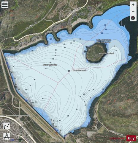
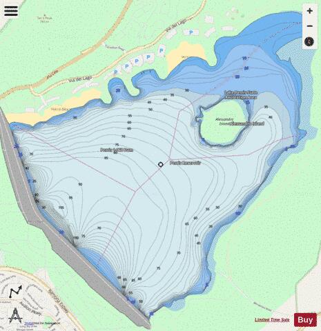
Perris Reservoir Fishing Map Stats | |
| Title | Perris Reservoir |
| Scale | 1:24000 |
| Counties | Riverside |
| Nearby Cities | Lakeview, Moreno, Nuevo, Perris, Moreno Valley, Sunnymead, Romoland, Edgemont, El Casco, Menifee |
| Area * | 1922.15 acres |
| Shoreline * | 10.41 miles |
| Min Longitude | -117.20 |
| Min Latitude | 33.84 |
| Max Longitude | -117.15 |
| Max Latitude | 33.87 |
| Edition Label 1 | |
| Edition Label 2 | |
| Edition Label 3 | |
| Id | US_AA_CA_00247390 |
| Country | US |
| Projection | Mercator |
| * some Stats may include nearby/connecting waterbodies | |
|