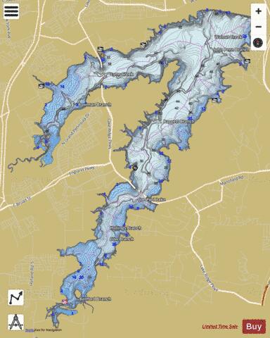
Joe Pool Lake fishing map is available as part of iBoating : USA Marine & Fishing App(now supported on multiple platforms including Android, iPhone/iPad, MacBook, and Windows(tablet and phone)/PC based chartplotter.).
With our Lake Maps App, you get all the great marine chart app features like fishing spots, along with Joe Pool Lake depth map. The fishing maps app include HD lake depth contours, along with advanced features found in Fish Finder / Gps Chart Plotter systems, turning your device into a Depth Finder. The Joe Pool Lake Navigation App provides advanced features of a Marine Chartplotter including adjusting water level offset and custom depth shading. Fishing spots and depth contours layers are available in most Lake maps. Lake navigation features include advanced instrumentation to gather wind speed direction, water temperature, water depth, and accurate GPS with AIS receivers(using NMEA over TCP/UDP). Autopilot support can be enabled during ‘Goto WayPoint’ and ‘Route Assistance’.
Now i-Boating supports Fishing Points in Joe Pool Lake.
Have more questions about the Nautical Chart App? Ask us.
Fishing Info for Joe Pool Lake
Joe Pool Lake is a fresh water impoundment (reservoir) located in the southern part of the Dallas/Fort Worth Metroplex in North Texas. The lake encompasses parts of Tarrant, Dallas and Ellis counties. The lake measures 7,740 acres (31.3 km2) with a conservation storage capacity of 176,900 acre-feet (218,200,000 m3). With a maximum depth of 75 feet (23 m) the lake drains an area of 232 square miles (601 km2). Joe Pool Lake was named after Joe R. Pool, a Congressman-At-Large from the Oak Cliff area of Dallas who represented this area as well as the rest of the state of Texas from 1963 until his death in 1968. Pool was highly influential in the passage of legislation and funding of the lake. The project to build Joe Pool Lake initiated by a promise made in 1961 by Kennedy/Johnson Natural Resources Advisory Committee member Joe Pool and was carried out by a citizens committee called the Lakeview (Joe Pool) Planning Council. His project was approved by Congress in 1965 and known as Lakeview Lake until 1982 when president Ronald W. Reagan signed a bill to rename the lake to Joe Pool Lake. Actual construction began in 1977, bridge work finished in 1981, with lake completion in December 1985. Impoundment of water began in January 1986 and the lake was filled by June 1989. On May 24, 1986 Joe Pool Lake was dedicated to the public with 1,500 people in attendance.
More on Wikipedia...Popular fish species in this lake include Crappie and Largemouth bass.
Joe Pool Lake Fishing Map Stats | |
| Title | Joe Pool Lake |
| Scale | 1:24000 |
| Counties | Dallas, Ellis, Tarrant |
| Nearby Cities | Britton, Webb, Florence Hill, Cedar Hill, Duncanville, Sublett, Mansfield, Midlothian, Lakeland Heights, Johnsons Station |
| Area * | 6494.67 acres |
| Shoreline * | 62.40 miles |
| Min Longitude | -97.08 |
| Min Latitude | 32.54 |
| Max Longitude | -96.98 |
| Max Latitude | 32.64 |
| Edition Label 1 | |
| Edition Label 2 | |
| Edition Label 3 | |
| Id | US_TX_01377217 |
| Country | US |
| Projection | Mercator |
| * some Stats may include nearby/connecting waterbodies | |
|


