Oologah Lake fishing map is available as part of iBoating : USA Marine & Fishing App(now supported on multiple platforms including Android, iPhone/iPad, MacBook, and Windows(tablet and phone)/PC based chartplotter.).
With our Lake Maps App, you get all the great marine chart app features like fishing spots, along with Oologah Lake depth map. The fishing maps app include HD lake depth contours, along with advanced features found in Fish Finder / Gps Chart Plotter systems, turning your device into a Depth Finder. The Oologah Lake Navigation App provides advanced features of a Marine Chartplotter including adjusting water level offset and custom depth shading. Fishing spots and depth contours layers are available in most Lake maps. Lake navigation features include advanced instrumentation to gather wind speed direction, water temperature, water depth, and accurate GPS with AIS receivers(using NMEA over TCP/UDP). Autopilot support can be enabled during ‘Goto WayPoint’ and ‘Route Assistance’.
Now i-Boating supports Fishing Points in Oologah Lake.
Have more questions about the Nautical Chart App? Ask us.
Fishing Info for Oologah Lake
Lake Oologah is a reservoir in northeastern Oklahoma. It is located near the towns of Oologah, Nowata, and Claremore. The lake has a surface of 29,500 acres (119 km2) of water and209 miles (336 km) of shoreline with 11 lake-side parks. The water storage capacity is rated as 552,210 acre-feet (681,140,000 m3). The lake is formed along the Verdigris River, and is a source of water for the Tulsa Metropolitan Area. The purpose of the dam and lake is flood control, water supply, navigation, recreation, and fish and wildlife.
More on Wikipedia...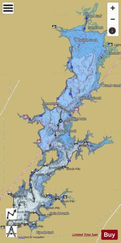
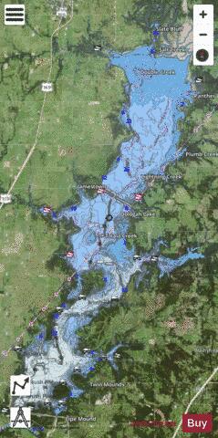
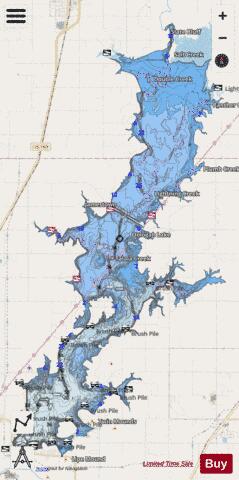
Oologah Lake Fishing Map Stats | |
| Title | Oologah Lake |
| Sailing Clubs in this Chart region | |
| Spindrift Sailing Club | |
| Scale | 1:12000 |
| Counties | Nowata, Rogers |
| Nearby Cities | Jamestown, New Alluwe, Foyil, Oologah, Chelsea, Watova, Talala, Nowata, Claremore, Delaware |
| Area * | 28024.12 acres |
| Shoreline * | 161.65 miles |
| Min Longitude | -95.68 |
| Min Latitude | 36.42 |
| Max Longitude | -95.52 |
| Max Latitude | 36.68 |
| Edition Label 1 | |
| Edition Label 2 | |
| Edition Label 3 | |
| Id | US_TU_OK_01096287 |
| Country | US |
| Projection | Mercator |
| * some Stats may include nearby/connecting waterbodies | |
|