Punished Woman fishing map is available as part of iBoating : USA Marine & Fishing App(now supported on multiple platforms including Android, iPhone/iPad, MacBook, and Windows(tablet and phone)/PC based chartplotter.).
With our Lake Maps App, you get all the great marine chart app features like fishing spots, along with Punished Woman lake depth map. The fishing maps app include HD lake depth contours, along with advanced features found in Fish Finder / Gps Chart Plotter systems, turning your device into a Depth Finder. The Punished Woman Navigation App provides advanced features of a Marine Chartplotter including adjusting water level offset and custom depth shading. Fishing spots and depth contours layers are available in most Lake maps. Lake navigation features include advanced instrumentation to gather wind speed direction, water temperature, water depth, and accurate GPS with AIS receivers(using NMEA over TCP/UDP). Autopilot support can be enabled during ‘Goto WayPoint’ and ‘Route Assistance’.
Now i-Boating supports Fishing Points in Punished Woman.
Have more questions about the Nautical Chart App? Ask us.
Fishing Info for Punished Woman
Punished Woman Lake is a natural glacial lake in northeastern South Dakota. It is located in Codington County, and borders the town of South Shore. The lake's surface area is 477 acres (193 ha), with approximately 4.5 miles (7.2 km) of shoreline. The average water depth is around 12 feet (3.7 m). Punished Woman Lake is managed by the South Dakota Game, Fish, and Parks (SDGFP) agency as a fishery for northern pike and yellow perch. The lake is also inhabited by black bullhead, common carp, golden shiner, walleye, and white suckerfish. Due to the lake's shallow waters, fish kills during extreme summer or winter temperatures are not unusual, and the SDGFP re-stocks the lake's primary species as needed.
More on Wikipedia...Popular fish species in this lake include Black bullhead, Common carp, Golden shiner, Northern pike, Walleye, White suckerfish and Yellow perch.
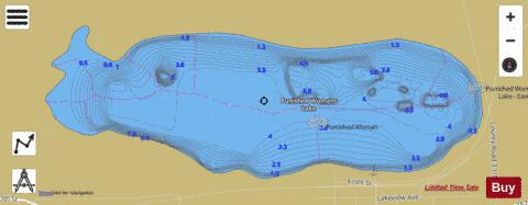
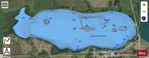
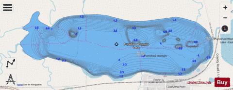
Punished Woman Fishing Map Stats | |
| Title | Punished Woman |
| Scale | 1:12000 |
| Counties | Codington |
| Nearby Cities | South Shore, Troy, Waverly, Stockholm, Marvin, Twin Brooks, Strandburg, Summit, Kranzburg, Goodwin |
| Area * | 479.23 acres |
| Shoreline * | 4.28 miles |
| Min Longitude | -96.96 |
| Min Latitude | 45.11 |
| Max Longitude | -96.92 |
| Max Latitude | 45.12 |
| Edition Label 1 | |
| Edition Label 2 | |
| Edition Label 3 | |
| Id | US_SD_punished_woman_codington_sd |
| Country | US |
| Projection | Mercator |
| * some Stats may include nearby/connecting waterbodies | |
|