Pactola fishing map is available as part of iBoating : USA Marine & Fishing App(now supported on multiple platforms including Android, iPhone/iPad, MacBook, and Windows(tablet and phone)/PC based chartplotter.).
With our Lake Maps App, you get all the great marine chart app features like fishing spots, along with Pactola lake depth map. The fishing maps app include HD lake depth contours, along with advanced features found in Fish Finder / Gps Chart Plotter systems, turning your device into a Depth Finder. The Pactola Navigation App provides advanced features of a Marine Chartplotter including adjusting water level offset and custom depth shading. Fishing spots and depth contours layers are available in most Lake maps. Lake navigation features include advanced instrumentation to gather wind speed direction, water temperature, water depth, and accurate GPS with AIS receivers(using NMEA over TCP/UDP). Autopilot support can be enabled during ‘Goto WayPoint’ and ‘Route Assistance’.
Now i-Boating supports Fishing Points in Pactola.
Have more questions about the Nautical Chart App? Ask us.
Fishing Info for Pactola
Pactola Lake is the largest and deepest reservoir in the Black Hills, located 15 miles west of Rapid City, South Dakota, United States. Constructed in 1952, the dam and waters are managed by the Bureau of Reclamation, with the surrounding land managed by the US Forest Service as part of Black Hills National Forest, which operates a visitor center located on the south side of the dam. Facilities include campgrounds, hiking trails, picnic areas, and a beach.
More on Wikipedia...Popular fish species in this lake include Lake trout.
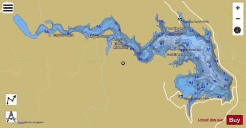
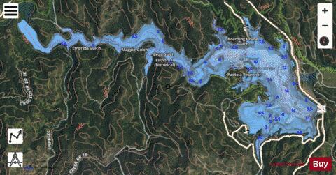
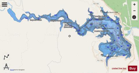
Pactola Fishing Map Stats | |
| Title | Pactola |
| Scale | 1:12000 |
| Counties | Pennington |
| Nearby Cities | Silver City, Johnson Siding, Nemo, Hill City, Rockerville, Rochford, Colonial Pine Hills, Keystone, Piedmont, Summerset |
| Area * | 822.63 acres |
| Shoreline * | 18.01 miles |
| Min Longitude | -103.56 |
| Min Latitude | 44.06 |
| Max Longitude | -103.48 |
| Max Latitude | 44.09 |
| Edition Label 1 | |
| Edition Label 2 | |
| Edition Label 3 | |
| Id | US_SD_pactola_pennington_sd |
| Country | US |
| Projection | Mercator |
| * some Stats may include nearby/connecting waterbodies | |
|