Wickiup Reservoir fishing map is available as part of iBoating : USA Marine & Fishing App(now supported on multiple platforms including Android, iPhone/iPad, MacBook, and Windows(tablet and phone)/PC based chartplotter.).
With our Lake Maps App, you get all the great marine chart app features like fishing spots, along with Wickiup Reservoir depth map. The fishing maps app include HD lake depth contours, along with advanced features found in Fish Finder / Gps Chart Plotter systems, turning your device into a Depth Finder. The Wickiup Reservoir Navigation App provides advanced features of a Marine Chartplotter including adjusting water level offset and custom depth shading. Fishing spots and depth contours layers are available in most Lake maps. Lake navigation features include advanced instrumentation to gather wind speed direction, water temperature, water depth, and accurate GPS with AIS receivers(using NMEA over TCP/UDP). Autopilot support can be enabled during ‘Goto WayPoint’ and ‘Route Assistance’.
Now i-Boating supports Fishing Points in Wickiup Reservoir.
Have more questions about the Nautical Chart App? Ask us.
Fishing Info for Wickiup Reservoir
Wickiup Reservoir is the second-largest reservoir in the U.S. state of Oregon. It is located 60 miles (97 km) southwest of Bend, and is the largest of the Cascade Lakes. Wickiup Reservoir is close to the Twin Lakes, Davis Lake, Crane Prairie Reservoir, Cultus Lake, and Little Cultus Lake. The reservoir is located within the Deschutes National Forest and the , near the Cascade Lakes Scenic Byway. Like nearby Crane Prairie Reservoir, Wickiup Reservoir was created by damming of the Deschutes River. The Wickiup Dam was built in 1949 by the United States Bureau of Reclamation for the "Deschutes Project" and "Pringle Falls Experimental Forest", which is used for education and research. Other nearby dams include the Crane Prairie Dam and the Haystack Dam. Wickiup Reservoir's earthen dam is 2.6 miles (4.2 km) long. The Deschutes River, which originates at Little Lava Lake, is an inflow and an outflow of Wickiup Reservoir. The average depth of the reservoir is 20 feet (6.1 m), with depths up to 70 feet (21 m) in channels. Because of this, fishing is very popular in the lake, especially for brown trout. Wickiup Reservoir is dubbed as the best lake for brown trout fishing in the state. The trout average between 5 and 8 pounds (2.3 and 3.6 kg), but some reach over 20 pounds (9.1 kg). According to the United States Forest Service, Wickiup Reservoir is one of Central Oregon's best wildlife viewing areas. Some of the nature that thrives in the area include waterfowl, shorebirds, hoofed mammals, ponderosa pine, and lodgepole pine. Also at Wickiup Reservoir are several recreation options. There are six campgrounds on site, all of which include a boat ramp, toilets and water. On August 12, 2009, the Oregon Department of Human Services issued a health advisory due to a large algae bloom. They mentioned that "drinking water from Wickiup Reservoir was dangerous, even if boiled or treated" and that anyone who relies on the water from the lake should find an alternate source.
More on Wikipedia...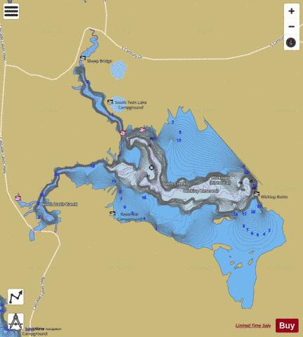
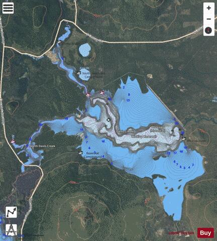
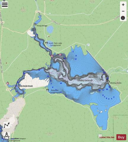
Wickiup Reservoir Fishing Map Stats | |
| Title | Wickiup Reservoir |
| Scale | 1:12000 |
| Counties | Deschutes |
| Nearby Cities | Gilchrist, Crescent, La Pine, Crescent Lake, Chemult, McCredie Springs, Bend, McKenzie Bridge, Diamond Lake, Tumalo |
| Area * | 10170.16 acres |
| Shoreline * | 53.17 miles |
| Min Longitude | -121.82 |
| Min Latitude | 43.63 |
| Max Longitude | -121.67 |
| Max Latitude | 43.74 |
| Edition Label 1 | |
| Edition Label 2 | |
| Edition Label 3 | |
| Id | US_OR_ordfw_wickiup_reservoir |
| Country | US |
| Projection | Mercator |
| * some Stats may include nearby/connecting waterbodies | |
|