Minam Lake fishing map is available as part of iBoating : USA Marine & Fishing App(now supported on multiple platforms including Android, iPhone/iPad, MacBook, and Windows(tablet and phone)/PC based chartplotter.).
With our Lake Maps App, you get all the great marine chart app features like fishing spots, along with Minam Lake depth map. The fishing maps app include HD lake depth contours, along with advanced features found in Fish Finder / Gps Chart Plotter systems, turning your device into a Depth Finder. The Minam Lake Navigation App provides advanced features of a Marine Chartplotter including adjusting water level offset and custom depth shading. Fishing spots and depth contours layers are available in most Lake maps. Lake navigation features include advanced instrumentation to gather wind speed direction, water temperature, water depth, and accurate GPS with AIS receivers(using NMEA over TCP/UDP). Autopilot support can be enabled during ‘Goto WayPoint’ and ‘Route Assistance’.
Now i-Boating supports Fishing Points in Minam Lake.
Have more questions about the Nautical Chart App? Ask us.
Fishing Info for Minam Lake
Minam Lake is a high-elevation reservoir in the Eagle Cap Wilderness of the Wallowa Mountains in the U.S. state of Oregon. The unusual reservoir, a modified natural lake, has outlets on both its north and south ends. The south outlet drains to the Minam River, and the north outlet is the source of the Lostine River. A natural lake at this spot had only a south outlet. In the early 20th century, the lake was enlarged and its flow altered by a 14-foot (4.3 m) high dam near the south end of the lake. The dam's purpose was to store additional water and to deflect it north for irrigation of farms in the Lostine Valley. It is said that minam is a word that evolved in the mid-19th century from the native word e-mi-ne-mah. The latter referred to the Minam River Valley, where a kind of plant with edible roots grew in abundance. Mah was a suffix meaning valley or canyon.
More on Wikipedia...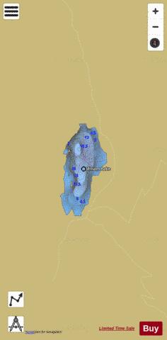

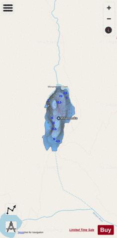
Minam Lake Fishing Map Stats | |
| Title | Minam Lake |
| Scale | 1:3000 |
| Counties | Wallowa |
| Nearby Cities | Joseph, Cornucopia, Enterprise, Lostine, Pondosa, Halfway, Keating, Pine, Wallowa, Richland |
| Area * | 58.69 acres |
| Shoreline * | 1.69 miles |
| Min Longitude | -117.36 |
| Min Latitude | 45.18 |
| Max Longitude | -117.35 |
| Max Latitude | 45.19 |
| Edition Label 1 | |
| Edition Label 2 | |
| Edition Label 3 | |
| Id | US_OR_ordfw_minam_lake |
| Country | US |
| Projection | Mercator |
| * some Stats may include nearby/connecting waterbodies | |
|