Miller Lake fishing map is available as part of iBoating : USA Marine & Fishing App(now supported on multiple platforms including Android, iPhone/iPad, MacBook, and Windows(tablet and phone)/PC based chartplotter.).
With our Lake Maps App, you get all the great marine chart app features like fishing spots, along with Miller Lake depth map. The fishing maps app include HD lake depth contours, along with advanced features found in Fish Finder / Gps Chart Plotter systems, turning your device into a Depth Finder. The Miller Lake Navigation App provides advanced features of a Marine Chartplotter including adjusting water level offset and custom depth shading. Fishing spots and depth contours layers are available in most Lake maps. Lake navigation features include advanced instrumentation to gather wind speed direction, water temperature, water depth, and accurate GPS with AIS receivers(using NMEA over TCP/UDP). Autopilot support can be enabled during ‘Goto WayPoint’ and ‘Route Assistance’.
Now i-Boating supports Fishing Points in Miller Lake.
Have more questions about the Nautical Chart App? Ask us.
Fishing Info for Miller Lake
Miller Lake is a large natural freshwater lake in the Cascade Range in western Klamath County in the U.S. state of Oregon. The lake is in the Winema National Forest, about 14 miles (23 km) west of Chemult via Miller Lake Road (Forest Road 9772). Recreation at the lake includes fishing for stocked rainbow and brown trout and kokanee. The lake has been called "one of the best brown trout fisheries in the state". Many brown trout in the lake, which is open for night fishing as well as day fishing, exceed 26 inches (66 cm) in length. The lake and its drainage system form the sole habitat for the Miller Lake lamprey. The species was nearly exterminated during the 1950s by state wildlife managers, who saw it as a threat to trout populations in the lake. Since its rediscovery in 1992, efforts have been underway to rebuild lamprey populations and reintroduce it to Miller Lake. Miller Lake is also used for swimming and non-motorized boating. Hiking trails in the vicinity provide access to the Mount Thielsen Wilderness and the Pacific Crest Trail. Digit Point Campground at the lake has 64 individual camping sites with access to picnic tables, potable water, and toilets. Mosquito infestations may require repellent or headnets.
More on Wikipedia...Popular fish species in this lake include Miller Lake lamprey and Rainbow trout.
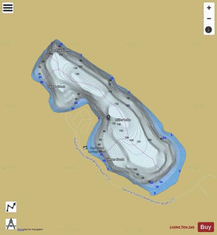

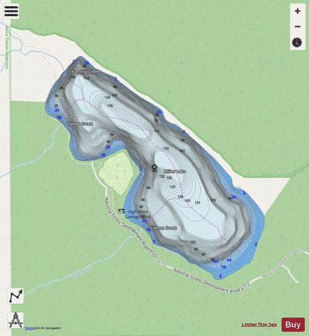
Miller Lake Fishing Map Stats | |
| Title | Miller Lake |
| Scale | 1:6000 |
| Counties | Klamath |
| Nearby Cities | Chemult, Diamond Lake, Crescent Lake, Crescent, Gilchrist, Kirk, Fort Klamath, McCredie Springs, Union Creek, Klamath Agency |
| Area * | 519.14 acres |
| Shoreline * | 4.47 miles |
| Min Longitude | -121.97 |
| Min Latitude | 43.22 |
| Max Longitude | -121.95 |
| Max Latitude | 43.24 |
| Edition Label 1 | |
| Edition Label 2 | |
| Edition Label 3 | |
| Id | US_OR_ordfw_miller_lake |
| Country | US |
| Projection | Mercator |
| * some Stats may include nearby/connecting waterbodies | |
|