Lake Oswego fishing map is available as part of iBoating : USA Marine & Fishing App(now supported on multiple platforms including Android, iPhone/iPad, MacBook, and Windows(tablet and phone)/PC based chartplotter.).
With our Lake Maps App, you get all the great marine chart app features like fishing spots, along with Lake Oswego depth map. The fishing maps app include HD lake depth contours, along with advanced features found in Fish Finder / Gps Chart Plotter systems, turning your device into a Depth Finder. The Lake Oswego Navigation App provides advanced features of a Marine Chartplotter including adjusting water level offset and custom depth shading. Fishing spots and depth contours layers are available in most Lake maps. Lake navigation features include advanced instrumentation to gather wind speed direction, water temperature, water depth, and accurate GPS with AIS receivers(using NMEA over TCP/UDP). Autopilot support can be enabled during ‘Goto WayPoint’ and ‘Route Assistance’.
Now i-Boating supports Fishing Points in Lake Oswego.
Have more questions about the Nautical Chart App? Ask us.
Fishing Info for Lake Oswego
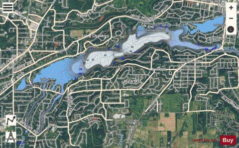
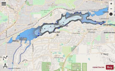
Oswego Lake is a lake in Clackamas County, Oregon that is completely surrounded by the city of Lake Oswego. Though the lake is naturally occurring (a former channel of the Tualatin River), it has been significantly altered because of the concrete dam that has increased its size to 431.7 acres (1.747 km2). The United States Geological Survey records the official name as Lake Oswego and, because of its artificially increased size, classifies it as a reservoir. To distinguish it from the city, however, the lake is usually called Oswego Lake.
More on Wikipedia...Popular fish species in this lake include Catostomidae.
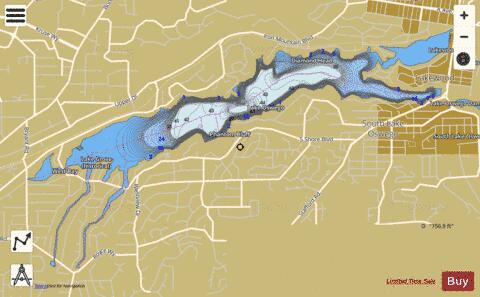
Lake Oswego Fishing Map Stats | |
| Title | Lake Oswego |
| Scale | 1:6000 |
| Counties | Clackamas |
| Nearby Cities | Lake Oswego, Rivergrove, Oak Grove, Durham, Stafford, Milwaukie, Tualatin, Tigard, Jennings Lodge, Metzger |
| Area * | 431.75 acres |
| Shoreline * | 13.70 miles |
| Min Longitude | -122.72 |
| Min Latitude | 45.39 |
| Max Longitude | -122.66 |
| Max Latitude | 45.42 |
| Edition Label 1 | |
| Edition Label 2 | |
| Edition Label 3 | |
| Id | US_OR_ordfw_lake_oswego |
| Country | US |
| Projection | Mercator |
| * some Stats may include nearby/connecting waterbodies | |
|