Lake of the Woods fishing map is available as part of iBoating : USA Marine & Fishing App(now supported on multiple platforms including Android, iPhone/iPad, MacBook, and Windows(tablet and phone)/PC based chartplotter.).
With our Lake Maps App, you get all the great marine chart app features like fishing spots, along with Lake of the Woods depth map. The fishing maps app include HD lake depth contours, along with advanced features found in Fish Finder / Gps Chart Plotter systems, turning your device into a Depth Finder. The Lake of the Woods Navigation App provides advanced features of a Marine Chartplotter including adjusting water level offset and custom depth shading. Fishing spots and depth contours layers are available in most Lake maps. Lake navigation features include advanced instrumentation to gather wind speed direction, water temperature, water depth, and accurate GPS with AIS receivers(using NMEA over TCP/UDP). Autopilot support can be enabled during ‘Goto WayPoint’ and ‘Route Assistance’.
Now i-Boating supports Fishing Points in Lake of the Woods.
Have more questions about the Nautical Chart App? Ask us.
Fishing Info for Lake of the Woods
Lake of the Woods is a natural lake near the crest of the Cascade Range in the Fremont–Winema National Forest in southern Oregon in the United States. The lake covers 1,146 acres (4.64 km2). It was named by Oliver C. Applegate in 1870. Today, the Oregon Department of Fish and Wildlife manages the lake's fishery. The small unincorporated community of Lake of the Woods is located on the east shore of the lake. Lake of the Woods is one of southern Oregon's most popular outdoor recreation sites.
More on Wikipedia...Popular fish species in this lake include Black crappie, Blue chub, Brook trout, Brown bullhead, Catostomidae, Largemouth bass, Pumpkinseed, Rainbow trout, Tui chub, Warmouth and Yellow perch.
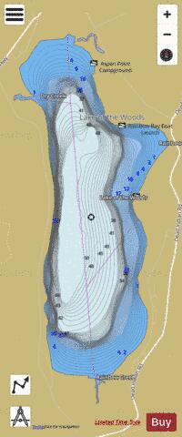
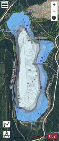
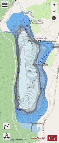
Lake of the Woods Fishing Map Stats | |
| Title | Lake of the Woods |
| Scale | 1:6000 |
| Counties | Klamath |
| Nearby Cities | Keno, Klamath Agency, Butte Falls, Fort Klamath, Chiloquin, Lake Creek, Klamath Falls, Midland, Prospect, Worden |
| Area * | 1231.67 acres |
| Shoreline * | 8.90 miles |
| Min Longitude | -122.23 |
| Min Latitude | 42.35 |
| Max Longitude | -122.20 |
| Max Latitude | 42.39 |
| Edition Label 1 | |
| Edition Label 2 | |
| Edition Label 3 | |
| Id | US_OR_ordfw_lake_of_the_woods |
| Country | US |
| Projection | Mercator |
| * some Stats may include nearby/connecting waterbodies | |
|