Goose Lake fishing map is available as part of iBoating : USA Marine & Fishing App(now supported on multiple platforms including Android, iPhone/iPad, MacBook, and Windows(tablet and phone)/PC based chartplotter.).
With our Lake Maps App, you get all the great marine chart app features like fishing spots, along with Goose Lake depth map. The fishing maps app include HD lake depth contours, along with advanced features found in Fish Finder / Gps Chart Plotter systems, turning your device into a Depth Finder. The Goose Lake Navigation App provides advanced features of a Marine Chartplotter including adjusting water level offset and custom depth shading. Fishing spots and depth contours layers are available in most Lake maps. Lake navigation features include advanced instrumentation to gather wind speed direction, water temperature, water depth, and accurate GPS with AIS receivers(using NMEA over TCP/UDP). Autopilot support can be enabled during ‘Goto WayPoint’ and ‘Route Assistance’.
Have more questions about the Nautical Chart App? Ask us.
Fishing Info for Goose Lake
Goose Lake is a large alkaline lake in the Goose Lake Valley on the Oregon–California border in the United States. Like many other lakes in the Great Basin, it is a pluvial lake that formed from precipitation and melting glaciers during the Pleistocene epoch. The north portion of the lake is in Lake County, Oregon, and the south portion is in Modoc County, California. The mountains at the north end of the lake are part of the Fremont National Forest, and the south end of the lake is adjacent to Modoc National Forest lands. Most of the valley property around the lake is privately owned agricultural land, though Goose Lake State Recreation Area is on the Oregon side of the lake. Goose Lake is the center of a semi-closed drainage basin. Its watershed is normally endorheic, but sometimes flows into the Pit River, part of the Sacramento River watershed, during periods of high water following heavy rainfall or snowmelt. During the 1970s and 1980s, the USGS defined Goose Lake as part of the Sacramento's watershed, but has redefined Goose Lake's watershed as a closed basin.
More on Wikipedia...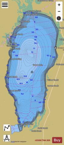
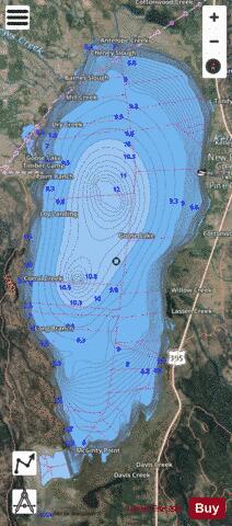
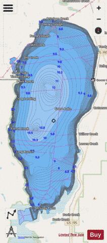
Goose Lake Fishing Map Stats | |
| Title | Goose Lake |
| Scale | 1:12000 |
| Counties | Modoc, Lake |
| Nearby Cities | Willow Ranch, New Pine Creek, New Pine Creek, Lakeview, Fort Bidwell, Lake City, Alturas, Cedarville, California Pines, Valley Falls |
| Area * | 94633.95 acres |
| Shoreline * | 79.83 miles |
| Min Longitude | -120.51 |
| Min Latitude | 41.76 |
| Max Longitude | -120.32 |
| Max Latitude | 42.09 |
| Edition Label 1 | |
| Edition Label 2 | |
| Edition Label 3 | |
| Id | US_OR_ordfw_goose_lake |
| Country | US |
| Projection | Mercator |
| * some Stats may include nearby/connecting waterbodies | |
|