Floras Lake fishing map is available as part of iBoating : USA Marine & Fishing App(now supported on multiple platforms including Android, iPhone/iPad, MacBook, and Windows(tablet and phone)/PC based chartplotter.).
With our Lake Maps App, you get all the great marine chart app features like fishing spots, along with Floras Lake depth map. The fishing maps app include HD lake depth contours, along with advanced features found in Fish Finder / Gps Chart Plotter systems, turning your device into a Depth Finder. The Floras Lake Navigation App provides advanced features of a Marine Chartplotter including adjusting water level offset and custom depth shading. Fishing spots and depth contours layers are available in most Lake maps. Lake navigation features include advanced instrumentation to gather wind speed direction, water temperature, water depth, and accurate GPS with AIS receivers(using NMEA over TCP/UDP). Autopilot support can be enabled during ‘Goto WayPoint’ and ‘Route Assistance’.
Now i-Boating supports Fishing Points in Floras Lake.
Have more questions about the Nautical Chart App? Ask us.
Fishing Info for Floras Lake
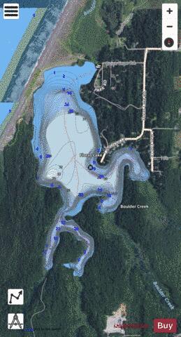
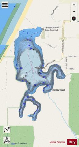
Floras Lake is a natural 236-acre (96 ha) body of water on the southern Oregon Coast of the United States. Fed by four small tributaries from a basin of about 10 square miles (26 km2) in Curry County, it lies about 10 miles (16 km) north of Port Orford and 2 miles (3 km) west of U.S. Route 101. It was probably named for Fred Flora, a 19th-century settler and miner who lived nearby. The lake, with a mean elevation of about 10 feet (3 m) above sea level, empties north into Floras Creek, where the combined streams form the New River. The river flows north behind a foredune until veering west and entering the Pacific Ocean through a break in the dune. Relatively remote, the lake and the 1,371-acre (555 ha) Floras Lake State Natural Area, can be reached on foot from the south along a 1.5-mile (2.4 km) trail that begins at Cape Blanco Airport. More common is to approach by car on Floras Lake Road off U.S. Route 101. This leads to Boice–Cope County Park, at the northeastern corner of the lake. The area near the lake, between Bandon to the north and Cape Blanco to the south, includes many state, federal, and county parks, recreation areas, and wildlife sanctuaries. Among those are the New River Area of Critical Environmental Concern (ACEC), overseen by the Bureau of Land Management north of the lake and west of the county park. The county park, which has campsites and day-use facilities, offers access to the New River ACEC as well as the lake.
More on Wikipedia...Popular fish species in this lake include Largemouth bass and Rainbow trout.
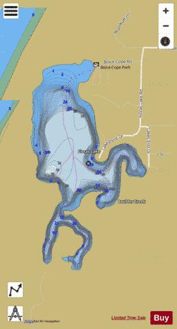
Floras Lake Fishing Map Stats | |
| Title | Floras Lake |
| Scale | 1:6000 |
| Counties | Curry |
| Nearby Cities | Langlois, Sixes, Port Orford, Bandon, Riverton, Ophir, Broadbent, Nesika Beach, Myrtle Point, Norway |
| Area * | 272.94 acres |
| Shoreline * | 5.64 miles |
| Min Longitude | -124.51 |
| Min Latitude | 42.88 |
| Max Longitude | -124.50 |
| Max Latitude | 42.90 |
| Edition Label 1 | |
| Edition Label 2 | |
| Edition Label 3 | |
| Id | US_OR_ordfw_floras_lake |
| Country | US |
| Projection | Mercator |
| * some Stats may include nearby/connecting waterbodies | |
|