Cougar Reservoir fishing map is available as part of iBoating : USA Marine & Fishing App(now supported on multiple platforms including Android, iPhone/iPad, MacBook, and Windows(tablet and phone)/PC based chartplotter.).
With our Lake Maps App, you get all the great marine chart app features like fishing spots, along with Cougar Reservoir depth map. The fishing maps app include HD lake depth contours, along with advanced features found in Fish Finder / Gps Chart Plotter systems, turning your device into a Depth Finder. The Cougar Reservoir Navigation App provides advanced features of a Marine Chartplotter including adjusting water level offset and custom depth shading. Fishing spots and depth contours layers are available in most Lake maps. Lake navigation features include advanced instrumentation to gather wind speed direction, water temperature, water depth, and accurate GPS with AIS receivers(using NMEA over TCP/UDP). Autopilot support can be enabled during ‘Goto WayPoint’ and ‘Route Assistance’.
Now i-Boating supports Fishing Points in Cougar Reservoir.
Have more questions about the Nautical Chart App? Ask us.
Fishing Info for Cougar Reservoir
Cougar Reservoir (also known as Cougar Lake) is a reservoir on the South Fork McKenzie River in the U.S. state of Oregon. It is in Lane County, 46 miles (74 km) east of Eugene and about 3 miles (5 km) south of the community of Rainbow in the Willamette National Forest. In 1963 the United States Army Corps of Engineers built Cougar Dam on the river primarily to generate hydroelectricity and control flooding, and the reservoir formed behind the dam. The lake is also used for recreation, including boating, fishing, swimming, and waterskiing. The United States Forest Service maintains three campgrounds—Cougar Crossing, Slide Creek, and Sunnyside—near the reservoir, with opportunities for hiking and picnicking as well as camping. Other campgrounds in the general vicinity include French Pete and Delta. Terwilliger Hot Springs is along Rider Creek just west of the lake. Cougar Reservoir supports populations of stocked rainbow trout and stocked landlocked Chinook salmon as well as naturally reproducing cutthroat trout. Fishing for rainbow trout, especially in winter, is said to be "fair". The lake also supports bull trout, but it is not legal to catch and keep them.
More on Wikipedia...Popular fish species in this lake include Bull trout and Rainbow trout.
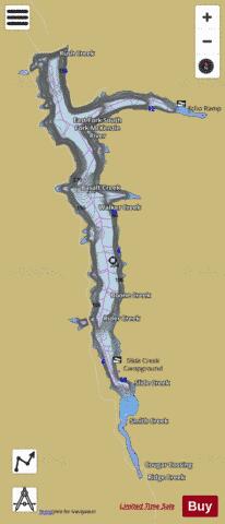
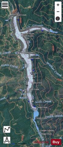

Cougar Reservoir Fishing Map Stats | |
| Title | Cougar Reservoir |
| Scale | 1:6000 |
| Counties | Lane |
| Nearby Cities | McKenzie Bridge, Blue River, Vida, McCredie Springs, Cascadia, Oakridge, Westfir, Leaburg, Foster, Walterville |
| Area * | 1142.75 acres |
| Shoreline * | 18.38 miles |
| Min Longitude | -122.25 |
| Min Latitude | 44.06 |
| Max Longitude | -122.21 |
| Max Latitude | 44.13 |
| Edition Label 1 | |
| Edition Label 2 | |
| Edition Label 3 | |
| Id | US_OR_ordfw_cougar_reservoir |
| Country | US |
| Projection | Mercator |
| * some Stats may include nearby/connecting waterbodies | |
|