Bull Run Lake fishing map is available as part of iBoating : USA Marine & Fishing App(now supported on multiple platforms including Android, iPhone/iPad, MacBook, and Windows(tablet and phone)/PC based chartplotter.).
With our Lake Maps App, you get all the great marine chart app features like fishing spots, along with Bull Run Lake depth map. The fishing maps app include HD lake depth contours, along with advanced features found in Fish Finder / Gps Chart Plotter systems, turning your device into a Depth Finder. The Bull Run Lake Navigation App provides advanced features of a Marine Chartplotter including adjusting water level offset and custom depth shading. Fishing spots and depth contours layers are available in most Lake maps. Lake navigation features include advanced instrumentation to gather wind speed direction, water temperature, water depth, and accurate GPS with AIS receivers(using NMEA over TCP/UDP). Autopilot support can be enabled during ‘Goto WayPoint’ and ‘Route Assistance’.
Now i-Boating supports Fishing Points in Bull Run Lake.
Have more questions about the Nautical Chart App? Ask us.
Fishing Info for Bull Run Lake
Bull Run Lake is a reservoir, an impoundment of the Bull Run River in the U.S. state of Oregon. Providing part of the primary drinking water supply for Portland, Oregon, it rates highly as an oligotrophic lake, a very clean source of water. As of 1925, noted geographer Lewis A. McArthur described the lake as one of the two most important in the state (along with Crater Lake), supplying the drinking water for a third of the state's population. The lake basin receives more than 110 inches (2,800 mm) of rain annually due to its location in the Cascade Range, about 9 miles (14 km) west of Mount Hood. Public access to the area has been controlled since June 17, 1892, with the creation of the Bull Run Reserve by President Benjamin Harrison. Water from the reservoir first flowed into the Portland water system on January 2, 1895. President Theodore Roosevelt restricted entry to all but government agents and water company employees and banned stock grazing on April 28, 1904. In 1915 a new timber and rock fill dam raised the lake level about 10 feet (3.0 m). At least two series of efforts were made between 1917 and 1925 to decrease lake seepage. In 1961 additional areas of seepage were sealed with clay, and the outlet dam was remodeled to contain gates at elevations of 3,147 feet (959 m) and 3,158 feet (963 m). In 1994, concerns of outflow water temperature and its effect on fish populations led to regular careful measurements of the lake's thermocline characteristics and the inlet water temperature. Concrete pier blocks were installed to minimize the effect of water temperature shock on downstream aquatic life.
More on Wikipedia...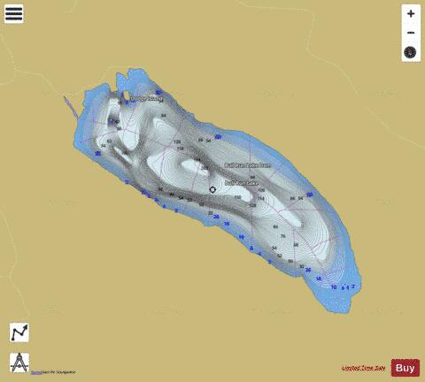
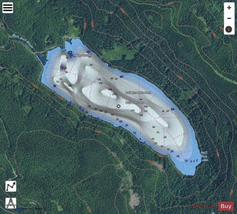
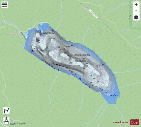
Bull Run Lake Fishing Map Stats | |
| Title | Bull Run Lake |
| Scale | 1:6000 |
| Counties | Clackamas, Multnomah |
| Nearby Cities | Rhododendron, Government Camp, Brightwood, Cascade Locks, North Bonneville, Parkdale, Dee, Stevenson, Carson, Mount Hood |
| Area * | 434.12 acres |
| Shoreline * | 4.66 miles |
| Min Longitude | -121.85 |
| Min Latitude | 45.45 |
| Max Longitude | -121.82 |
| Max Latitude | 45.46 |
| Edition Label 1 | |
| Edition Label 2 | |
| Edition Label 3 | |
| Id | US_OR_ordfw_bull_run_lake |
| Country | US |
| Projection | Mercator |
| * some Stats may include nearby/connecting waterbodies | |
|