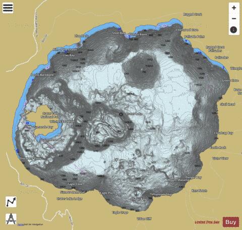
Crater Lake fishing map is available as part of iBoating : USA Marine & Fishing App(now supported on multiple platforms including Android, iPhone/iPad, MacBook, and Windows(tablet and phone)/PC based chartplotter.).
With our Lake Maps App, you get all the great marine chart app features like fishing spots, along with Crater Lake depth map. The fishing maps app include HD lake depth contours, along with advanced features found in Fish Finder / Gps Chart Plotter systems, turning your device into a Depth Finder. The Crater Lake Navigation App provides advanced features of a Marine Chartplotter including adjusting water level offset and custom depth shading. Fishing spots and depth contours layers are available in most Lake maps. Lake navigation features include advanced instrumentation to gather wind speed direction, water temperature, water depth, and accurate GPS with AIS receivers(using NMEA over TCP/UDP). Autopilot support can be enabled during ‘Goto WayPoint’ and ‘Route Assistance’.
Now i-Boating supports Fishing Points in Crater Lake.
Have more questions about the Nautical Chart App? Ask us.
Fishing Info for Crater Lake
Crater Lake (Klamath: Giiwas) is a volcanic crater lake in south-central Oregon in the western United States. It is the main feature of Crater Lake National Park and is famous for its deep blue color and water clarity. The lake partly fills a 2,148-foot-deep (655 m) caldera that was formed around 7,700 (± 150) years agoby the collapse of the volcano Mount Mazama. There are no rivers flowing into or out of the lake; the evaporation is compensated for by rain and snowfall at a rate such that the total amount of water is replaced every 250 years. With a depth of 1,949 feet (594 m), the lake is the deepest in the United States. In the world, it ranks ninth for maximum depth, and third for mean (average) depth. Crater Lake features two small islands. Wizard Island, located near the western shore of the lake, is a cinder cone approximately 316 acres (128 ha) in size. Phantom Ship, a natural rock pillar, is located near the southern shore. Since 2002, one of Oregon's regular-issue license plate designs has featured Crater Lake and a one-time plate surcharge is used to support the operation of Crater Lake National Park. The commemorative Oregon State Quarter, which was released by the United States Mint in 2005, features an image of Crater Lake on its reverse. The lake and surrounding park areas offer many recreational activities including hiking, biking, snowshoeing, fishing, and cross-country skiing are available, and during the summer, campgrounds and lodges at Crater Lake are open to visitors.
More on Wikipedia...Popular fish species in this lake include Rainbow trout.
Crater Lake Fishing Map Stats | |
| Title | Crater Lake |
| Scale | 1:12000 |
| Counties | Klamath |
| Nearby Cities | Diamond Lake, Fort Klamath, Union Creek, Kirk, Klamath Agency, Prospect, Chemult, Chiloquin, Crescent Lake, Butte Falls |
| Area * | 13211.30 acres |
| Shoreline * | 24.25 miles |
| Min Longitude | -122.16 |
| Min Latitude | 42.90 |
| Max Longitude | -122.05 |
| Max Latitude | 42.98 |
| Edition Label 1 | |
| Edition Label 2 | |
| Edition Label 3 | |
| Id | US_OR_01163669 |
| Country | US |
| Projection | Mercator |
| * some Stats may include nearby/connecting waterbodies | |
|


