Wallowa Lake fishing map is available as part of iBoating : USA Marine & Fishing App(now supported on multiple platforms including Android, iPhone/iPad, MacBook, and Windows(tablet and phone)/PC based chartplotter.).
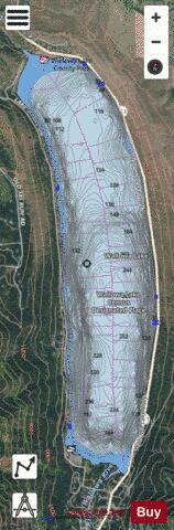
With our Lake Maps App, you get all the great marine chart app features like fishing spots, along with Wallowa Lake depth map. The fishing maps app include HD lake depth contours, along with advanced features found in Fish Finder / Gps Chart Plotter systems, turning your device into a Depth Finder. The Wallowa Lake Navigation App provides advanced features of a Marine Chartplotter including adjusting water level offset and custom depth shading. Fishing spots and depth contours layers are available in most Lake maps. Lake navigation features include advanced instrumentation to gather wind speed direction, water temperature, water depth, and accurate GPS with AIS receivers(using NMEA over TCP/UDP). Autopilot support can be enabled during ‘Goto WayPoint’ and ‘Route Assistance’.
Now i-Boating supports Fishing Points in Wallowa Lake.
Have more questions about the Nautical Chart App? Ask us.
Fishing Info for Wallowa Lake
Wallowa Lake is a ribbon lake 1 mile (1.6 km) south of Joseph, Oregon, United States, at an elevation of 4,372 ft (1,333 m). Impounded by high moraines, it was formed by a series of Pleistocene glaciers. On the south end of the lake is a small community made up of vacation homes, lodging, restaurants, as well as other small businesses. Wallowa Lake has been used for recreation since at least 1880. The Wallowa Lake State Park is at the southern tip of the lake.
More on Wikipedia...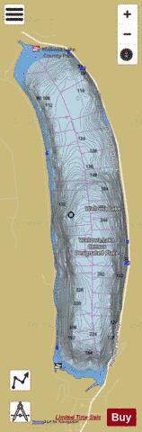
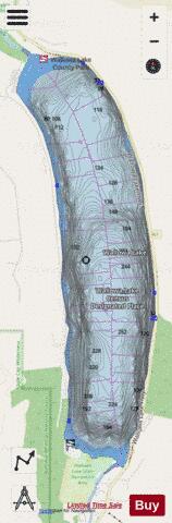
Wallowa Lake Fishing Map Stats | |
| Title | Wallowa Lake |
| Scale | 1:6000 |
| Counties | Wallowa |
| Nearby Cities | Joseph, Enterprise, Lostine, Cornucopia, Wallowa, Halfway, Pine, Homestead, Pondosa, Richland |
| Area * | 1592.12 acres |
| Shoreline * | 8.96 miles |
| Min Longitude | -117.22 |
| Min Latitude | 45.28 |
| Max Longitude | -117.20 |
| Max Latitude | 45.34 |
| Edition Label 1 | |
| Edition Label 2 | |
| Edition Label 3 | |
| Id | US_OR_01151862 |
| Country | US |
| Projection | Mercator |
| * some Stats may include nearby/connecting waterbodies | |
|