Lloyd Church Lake fishing map is available as part of iBoating : USA Marine & Fishing App(now supported on multiple platforms including Android, iPhone/iPad, MacBook, and Windows(tablet and phone)/PC based chartplotter.).
With our Lake Maps App, you get all the great marine chart app features like fishing spots, along with Lloyd Church Lake depth map. The fishing maps app include HD lake depth contours, along with advanced features found in Fish Finder / Gps Chart Plotter systems, turning your device into a Depth Finder. The Lloyd Church Lake Navigation App provides advanced features of a Marine Chartplotter including adjusting water level offset and custom depth shading. Fishing spots and depth contours layers are available in most Lake maps. Lake navigation features include advanced instrumentation to gather wind speed direction, water temperature, water depth, and accurate GPS with AIS receivers(using NMEA over TCP/UDP). Autopilot support can be enabled during ‘Goto WayPoint’ and ‘Route Assistance’.
Now i-Boating supports Fishing Points in Lloyd Church Lake.
Have more questions about the Nautical Chart App? Ask us.
Fishing Info for Lloyd Church Lake
Lloyd Church Lake is a reservoir located south of the city of Wilburton, Oklahoma on a tributary of the Fourche Maline river. The lake is supported by an earthen dam and was constructed in 1964. The lake has a normal capacity of 3,025 acre-feet (3,731,000 m3), covers 154 acres (0.62 km2), surrounded by 3.8 miles (6.1 km) of shoreline and has an average depth of 19.4 feet (5.9 m). The lake is operated by the city of Wilburton. It is also used for fishing.
More on Wikipedia...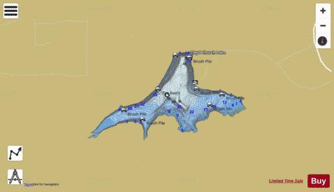
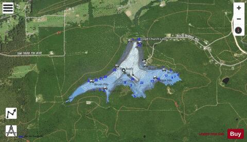
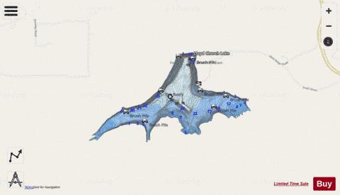
Lloyd Church Lake Fishing Map Stats | |
| Title | Lloyd Church Lake |
| Scale | 1:6000 |
| Counties | Latimer |
| Nearby Cities | Wilburton, Gowen, Yanush, Hartshorne, Red Oak, Quinton, Kinta, Tuskahoma, Haileyville, Clayton |
| Area * | 155.63 acres |
| Shoreline * | 3.81 miles |
| Min Longitude | -95.35 |
| Min Latitude | 34.87 |
| Max Longitude | -95.33 |
| Max Latitude | 34.88 |
| Edition Label 1 | |
| Edition Label 2 | |
| Edition Label 3 | |
| Id | US_OK_lloydchurch |
| Country | US |
| Projection | Mercator |
| * some Stats may include nearby/connecting waterbodies | |
|