Lake Claremore fishing map is available as part of iBoating : USA Marine & Fishing App(now supported on multiple platforms including Android, iPhone/iPad, MacBook, and Windows(tablet and phone)/PC based chartplotter.).
With our Lake Maps App, you get all the great marine chart app features like fishing spots, along with Lake Claremore depth map. The fishing maps app include HD lake depth contours, along with advanced features found in Fish Finder / Gps Chart Plotter systems, turning your device into a Depth Finder. The Lake Claremore Navigation App provides advanced features of a Marine Chartplotter including adjusting water level offset and custom depth shading. Fishing spots and depth contours layers are available in most Lake maps. Lake navigation features include advanced instrumentation to gather wind speed direction, water temperature, water depth, and accurate GPS with AIS receivers(using NMEA over TCP/UDP). Autopilot support can be enabled during ‘Goto WayPoint’ and ‘Route Assistance’.
Now i-Boating supports Fishing Points in Lake Claremore.
Have more questions about the Nautical Chart App? Ask us.
Fishing Info for Lake Claremore
Claremore Lake is a reservoir in Rogers County, Oklahoma. Constructed in 1929-1930 by damming Dog Creek for the purpose of providing water to the city of Claremore, Oklahoma and houses recreational amenities such as boat ramps, fishing docks, and picnic areas. In 2011, the lake added a 9-hole disc golf course. The lake has a capacity of 7,900 acre-feet (9,700,000 m3), covers 470 acres (1.9 km2) Claremore Lake Park comprises 1,200 acres (4,900,000 m2) off of East Blue Starr Drive in Claremore. The park has two separate playgrounds and has picnic tables and grills available for public use. There are also two covered shelters with electrical outlets. Shelters can be rented through the Claremore Parks and Recreation Department. Camping is not allowed, and animals must be restrained at all times. Alcohol is prohibited.
More on Wikipedia...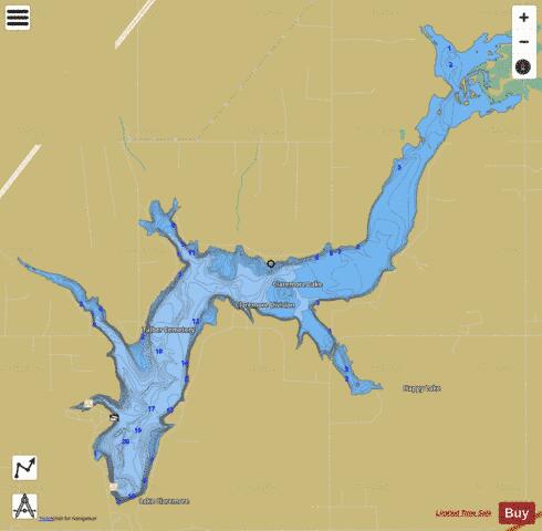
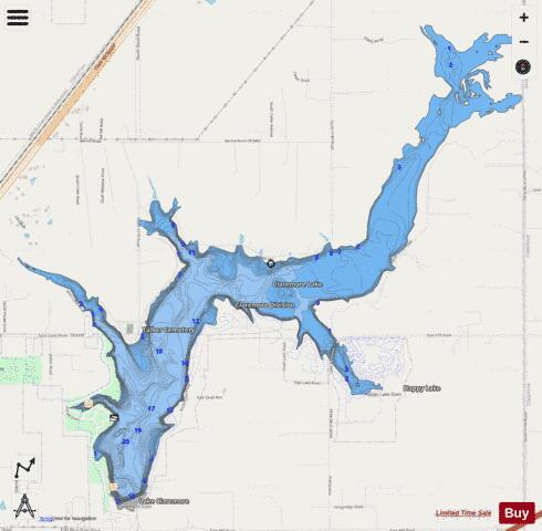
Lake Claremore Fishing Map Stats | |
| Title | Lake Claremore |
| Scale | 1:12000 |
| Counties | Rogers |
| Nearby Cities | Claremore, Tiawah, Foyil, Verdigris, Inola, Oologah, Chelsea, Fair Oaks, Catoosa, Talala |
| Area * | 621.73 acres |
| Shoreline * | 17.77 miles |
| Min Longitude | -95.59 |
| Min Latitude | 36.32 |
| Max Longitude | -95.54 |
| Max Latitude | 36.36 |
| Edition Label 1 | |
| Edition Label 2 | |
| Edition Label 3 | |
| Id | US_OK_claremore |
| Country | US |
| Projection | Mercator |
| * some Stats may include nearby/connecting waterbodies | |
|