Skiatook Lake fishing map is available as part of iBoating : USA Marine & Fishing App(now supported on multiple platforms including Android, iPhone/iPad, MacBook, and Windows(tablet and phone)/PC based chartplotter.).
With our Lake Maps App, you get all the great marine chart app features like fishing spots, along with Skiatook Lake depth map. The fishing maps app include HD lake depth contours, along with advanced features found in Fish Finder / Gps Chart Plotter systems, turning your device into a Depth Finder. The Skiatook Lake Navigation App provides advanced features of a Marine Chartplotter including adjusting water level offset and custom depth shading. Fishing spots and depth contours layers are available in most Lake maps. Lake navigation features include advanced instrumentation to gather wind speed direction, water temperature, water depth, and accurate GPS with AIS receivers(using NMEA over TCP/UDP). Autopilot support can be enabled during ‘Goto WayPoint’ and ‘Route Assistance’.
Now i-Boating supports Fishing Points in Skiatook Lake.
Have more questions about the Nautical Chart App? Ask us.
Fishing Info for Skiatook Lake
Skiatook Lake is a federally-owned and operated reservoir located in Osage County, Oklahoma, 4 miles (6.4 km) west of the town of Skiatook, 11 miles (18 km) east of Hominy, Oklahoma and about 18 miles (29 km) from Tulsa. The Skiatook Dam is located on Hominy Creek, 14 miles (23 km) upstream of the confluence of Hominy and Bird Creeks. The project purposes include flood control, water quality, water supply, recreation, and fish and wildlife management. The cities of Skiatook, Sand Springs, Sapulpa, and Tulsa use Skiatook Lake as a municipal water supply. Gentle rolling hills of Blackjack and Post Oak interspersed with Tallgrass prairie surround the lake. The lake is under the management of the U.S. Army Corps of Engineers, Tulsa District.
More on Wikipedia...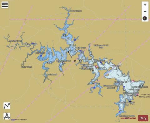

Skiatook Lake Fishing Map Stats | |
| Title | Skiatook Lake |
| Scale | 1:24000 |
| Counties | Osage |
| Nearby Cities | Skiatook, Sperry, Hominy, Barnsdall, Avant, Turley, Prue, Wynona, Osage, Westport |
| Area * | 10410.18 acres |
| Shoreline * | 181.91 miles |
| Min Longitude | -96.33 |
| Min Latitude | 36.30 |
| Max Longitude | -96.09 |
| Max Latitude | 36.46 |
| Edition Label 1 | |
| Edition Label 2 | |
| Edition Label 3 | |
| Id | US_OK_01100124 |
| Country | US |
| Projection | Mercator |
| * some Stats may include nearby/connecting waterbodies | |
|