Lake Sunapee fishing map is available as part of iBoating : USA Marine & Fishing App(now supported on multiple platforms including Android, iPhone/iPad, MacBook, and Windows(tablet and phone)/PC based chartplotter.).
With our Lake Maps App, you get all the great marine chart app features like fishing spots, along with Lake Sunapee depth map. The fishing maps app include HD lake depth contours, along with advanced features found in Fish Finder / Gps Chart Plotter systems, turning your device into a Depth Finder. The Lake Sunapee Navigation App provides advanced features of a Marine Chartplotter including adjusting water level offset and custom depth shading. Fishing spots and depth contours layers are available in most Lake maps. Lake navigation features include advanced instrumentation to gather wind speed direction, water temperature, water depth, and accurate GPS with AIS receivers(using NMEA over TCP/UDP). Autopilot support can be enabled during ‘Goto WayPoint’ and ‘Route Assistance’.
Now i-Boating supports Fishing Points in Lake Sunapee.
Have more questions about the Nautical Chart App? Ask us.
Fishing Info for Lake Sunapee
Lake Sunapee is located within Sullivan County and Merrimack County in western New Hampshire, the United States. It is the fifth-largest lake located entirely in New Hampshire. The lake is approximately 8.1 miles (13.0 km) long (north-south) and from 0.5 to 2.5 miles (0.8 to 4.0 km) wide (east-west), covering 6.5 square miles (17 km2), with a maximum depth of 105 feet (32 m). It contains eleven islands (Loon Island, Elizabeth Island, Twin Islands, Great Island, Minute Island, Little Island, Star Island, Emerald Island, Isle of Pines and Penny Island) and is indented by several peninsulas and lake fingers, a combination which yields a total shoreline of some 70 miles (110 km). There are seven sandy beach areas including Mount Sunapee State Park beach; some with restricted town access. There are six boat ramps to access the lake at Sunapee Harbor, Georges Mills, Newbury, Mount Sunapee State Park, Burkehaven Marina, and a private marina. The lake contains three lighthouses on the National Register of Historic Places. The driving distance around the lake is 25 miles (40 km) with many miles of lake water view. The lake is 1,093 feet (333 m) above sea level. The lake's outlet is in Sunapee Harbor, the headway for the Sugar River, which flows west through Newport and Claremont to the Connecticut River and then to the Atlantic Ocean. The lake discharges about 250 cubic feet per second (on average), and the Sugar River drops approximately 800 feet (240 m) on its 27-mile (43 km) journey to the Connecticut River.
More on Wikipedia...Popular fish species in this lake include Atlantic salmon, Brook trout, Brown bullhead, Burbot, Chain pickerel, Lake trout, Rainbow smelt, Rock bass, Smallmouth bass and Yellow perch.
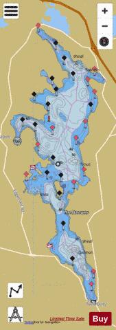
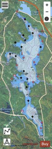
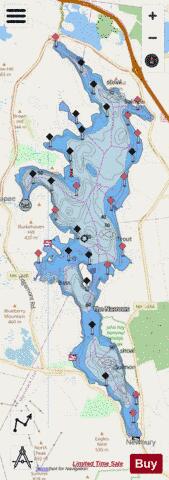
Lake Sunapee Fishing Map Stats | |
| Title | Lake Sunapee |
| Sailing Clubs in this Chart region | |
| Lake Sunapee Yacht Club | |
| Scale | 1:6000 |
| Counties | Merrimack, Sullivan |
| Nearby Cities | Blodgett Landing, Newbury, Georges Mills, Sunapee, New London, Springfield, Sutton, Grantham, Bradford, Newport |
| Area * | 4125.22 acres |
| Shoreline * | 32.96 miles |
| Min Longitude | -72.08 |
| Min Latitude | 43.32 |
| Max Longitude | -72.03 |
| Max Latitude | 43.43 |
| Edition Label 1 | |
| Edition Label 2 | |
| Edition Label 3 | |
| Id | US_NH_01775851 |
| Country | US |
| Projection | Mercator |
| * some Stats may include nearby/connecting waterbodies | |
|