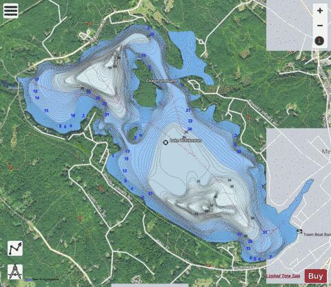
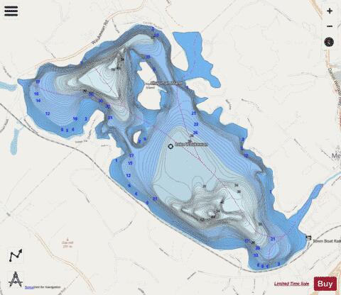
Lake Waukewan fishing map is available as part of iBoating : USA Marine & Fishing App(now supported on multiple platforms including Android, iPhone/iPad, MacBook, and Windows(tablet and phone)/PC based chartplotter.).
With our Lake Maps App, you get all the great marine chart app features like fishing spots, along with Lake Waukewan depth map. The fishing maps app include HD lake depth contours, along with advanced features found in Fish Finder / Gps Chart Plotter systems, turning your device into a Depth Finder. The Lake Waukewan Navigation App provides advanced features of a Marine Chartplotter including adjusting water level offset and custom depth shading. Fishing spots and depth contours layers are available in most Lake maps. Lake navigation features include advanced instrumentation to gather wind speed direction, water temperature, water depth, and accurate GPS with AIS receivers(using NMEA over TCP/UDP). Autopilot support can be enabled during ‘Goto WayPoint’ and ‘Route Assistance’.
Now i-Boating supports Fishing Points in Lake Waukewan.
Have more questions about the Nautical Chart App? Ask us.
Fishing Info for Lake Waukewan
Lake Waukewan is a 928-acre (3.76 km2) water body located in Belknap County in the Lakes Region of central New Hampshire, United States, in the towns of Meredith and New Hampton. The town of Center Harbor occupies part of the lake's northern shoreline. The lake is classified as a cold- and warmwater fishery, with observed species including rainbow trout, smallmouth bass, chain pickerel, horned pout, and white perch. It supplies drinking water for the town of Meredith from an inlet near the south end of the lake. The water level is controlled by the Dam Bureau of the New Hampshire Department of Environmental Services. As of 2013, it is maintained at 540.0 feet (164.6 m) above sea level in the summer, and 538.5 feet (164.1 m) the rest of the year. Water from Lake Waukewan flows into Lake Winnipesaukee, with a 40-foot (12 m) drop in elevation. The water rights to the natural Measly Pond Brook (a.k.a. Corliss Brook) was purchased by John Jenness in 1795, and used to power a gristmill and sawmill in Meredith Village, though it was not the best local waterpower source. John Bond Swasey redirected the flow into a 600-foot canal and consolidated waterfall (construction 1816-1818) which greatly improved the amount of waterpower available, allowing further industrialization of the village. (See Meredith, New Hampshire § History.)
More on Wikipedia...Popular fish species in this lake include Brown bullhead, Chain pickerel, Rainbow trout and Smallmouth bass.
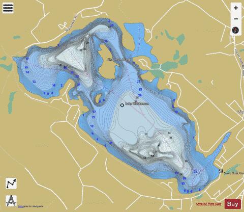
Lake Waukewan Fishing Map Stats | |
| Title | Lake Waukewan |
| Scale | 1:3000 |
| Counties | Belknap |
| Nearby Cities | Meredith, Winona, Holderness, Ashland, New Hampton, Laconia, Gilford, Moultonborough, Suissevale, Center Sandwich |
| Area * | 927.63 acres |
| Shoreline * | 10.26 miles |
| Min Longitude | -71.55 |
| Min Latitude | 43.65 |
| Max Longitude | -71.50 |
| Max Latitude | 43.67 |
| Edition Label 1 | |
| Edition Label 2 | |
| Edition Label 3 | |
| Id | US_NH_00870688 |
| Country | US |
| Projection | Mercator |
| * some Stats may include nearby/connecting waterbodies | |
|