Pearly Lake fishing map is available as part of iBoating : USA Marine & Fishing App(now supported on multiple platforms including Android, iPhone/iPad, MacBook, and Windows(tablet and phone)/PC based chartplotter.).
With our Lake Maps App, you get all the great marine chart app features like fishing spots, along with Pearly Lake depth map. The fishing maps app include HD lake depth contours, along with advanced features found in Fish Finder / Gps Chart Plotter systems, turning your device into a Depth Finder. The Pearly Lake Navigation App provides advanced features of a Marine Chartplotter including adjusting water level offset and custom depth shading. Fishing spots and depth contours layers are available in most Lake maps. Lake navigation features include advanced instrumentation to gather wind speed direction, water temperature, water depth, and accurate GPS with AIS receivers(using NMEA over TCP/UDP). Autopilot support can be enabled during ‘Goto WayPoint’ and ‘Route Assistance’.
Now i-Boating supports Fishing Points in Pearly Lake.
Have more questions about the Nautical Chart App? Ask us.
Fishing Info for Pearly Lake
Pearly Lake or Pearly Pond is a 192-acre (0.8 km2) water body in the town of Rindge, Cheshire County, southwestern New Hampshire, United States. Formerly known as Tarbell Pond, named for Revolutionary War Minuteman Lieut. Samuel Tarbell (1744-1828) who settled here, the lake is one of the headwaters of Tarbell Brook, a tributary of the Millers River, which flows southwest to the Connecticut River at Millers Falls, Massachusetts. The undergraduate campus of Franklin Pierce University is located on the northeast shore of the lake. The lake is classified as a warmwater fishery, with observed species including largemouth bass, chain pickerel, yellow perch, bluegill, horned pout, American eel, and green sunfish.
More on Wikipedia...Popular fish species in this lake include American eel, Brown bullhead, Chain pickerel, Green sunfish, Largemouth bass and Yellow perch.
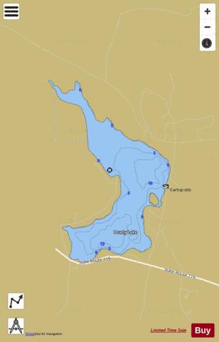
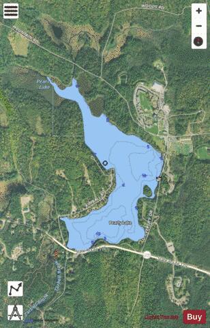
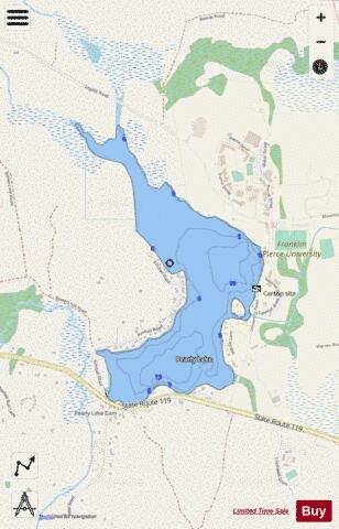
Pearly Lake Fishing Map Stats | |
| Title | Pearly Lake |
| Scale | 1:1500 |
| Counties | Cheshire |
| Nearby Cities | Jaffrey, Rindge, Fitzwilliam, Winchendon, Troy, Dublin, Peterborough, Sharon, Royalston, Baldwinville |
| Area * | 191.55 acres |
| Shoreline * | 4.26 miles |
| Min Longitude | -72.07 |
| Min Latitude | 42.77 |
| Max Longitude | -72.06 |
| Max Latitude | 42.78 |
| Edition Label 1 | |
| Edition Label 2 | |
| Edition Label 3 | |
| Id | US_NH_00869044 |
| Country | US |
| Projection | Mercator |
| * some Stats may include nearby/connecting waterbodies | |
|