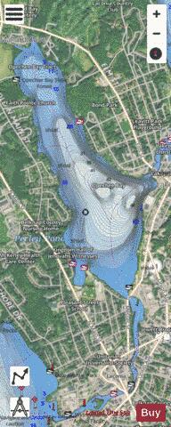
Opechee Bay fishing map is available as part of iBoating : USA Marine & Fishing App(now supported on multiple platforms including Android, iPhone/iPad, MacBook, and Windows(tablet and phone)/PC based chartplotter.).
With our Lake Maps App, you get all the great marine chart app features like fishing spots, along with Opechee Bay lake depth map. The fishing maps app include HD lake depth contours, along with advanced features found in Fish Finder / Gps Chart Plotter systems, turning your device into a Depth Finder. The Opechee Bay Navigation App provides advanced features of a Marine Chartplotter including adjusting water level offset and custom depth shading. Fishing spots and depth contours layers are available in most Lake maps. Lake navigation features include advanced instrumentation to gather wind speed direction, water temperature, water depth, and accurate GPS with AIS receivers(using NMEA over TCP/UDP). Autopilot support can be enabled during ‘Goto WayPoint’ and ‘Route Assistance’.
Now i-Boating supports Fishing Points in Opechee Bay.
Have more questions about the Nautical Chart App? Ask us.
Fishing Info for Opechee Bay
Opechee Bay is a 449-acre (1.82 km2) lake located in Belknap County in the Lakes Region of central New Hampshire, United States, in the city of Laconia. It is located directly downstream from Paugus Bay and Lake Winnipesaukee, and it connects by a one-mile segment of the Winnipesaukee River through the center of Laconia to Lake Winnisquam. The lake is classified as a cold- and warmwater fishery, with observed species including brook trout, rainbow trout, land-locked salmon, lake trout, lake whitefish, smallmouth and largemouth bass, chain pickerel, horned pout, white perch, black crappie, and bluegill.
More on Wikipedia...Popular fish species in this lake include Atlantic salmon, Black crappie, Brook trout, Brown bullhead, Chain pickerel, Lake trout, Lake whitefish, Largemouth bass, Rainbow trout and Smallmouth bass.
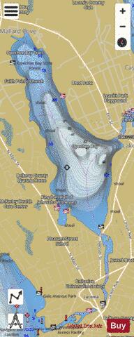
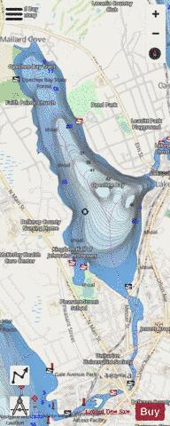
Opechee Bay Fishing Map Stats | |
| Title | Opechee Bay |
| Scale | 1:3000 |
| Counties | Belknap |
| Nearby Cities | Laconia, Gilford, Belmont, Meredith, Gilmanton, Sanbornton, Winona, Tilton, Tilton Northfield, Northfield |
| Area * | 448.91 acres |
| Shoreline * | 7.02 miles |
| Min Longitude | -71.48 |
| Min Latitude | 43.53 |
| Max Longitude | -71.46 |
| Max Latitude | 43.56 |
| Edition Label 1 | |
| Edition Label 2 | |
| Edition Label 3 | |
| Id | US_NH_00868914 |
| Country | US |
| Projection | Mercator |
| * some Stats may include nearby/connecting waterbodies | |
|