Mascoma Lake fishing map is available as part of iBoating : USA Marine & Fishing App(now supported on multiple platforms including Android, iPhone/iPad, MacBook, and Windows(tablet and phone)/PC based chartplotter.).
With our Lake Maps App, you get all the great marine chart app features like fishing spots, along with Mascoma Lake depth map. The fishing maps app include HD lake depth contours, along with advanced features found in Fish Finder / Gps Chart Plotter systems, turning your device into a Depth Finder. The Mascoma Lake Navigation App provides advanced features of a Marine Chartplotter including adjusting water level offset and custom depth shading. Fishing spots and depth contours layers are available in most Lake maps. Lake navigation features include advanced instrumentation to gather wind speed direction, water temperature, water depth, and accurate GPS with AIS receivers(using NMEA over TCP/UDP). Autopilot support can be enabled during ‘Goto WayPoint’ and ‘Route Assistance’.
Now i-Boating supports Fishing Points in Mascoma Lake.
Have more questions about the Nautical Chart App? Ask us.
Fishing Info for Mascoma Lake
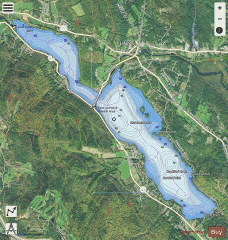
Mascoma Lake is a 1,158-acre (469 ha) lake in western New Hampshire, United States. Most of the lake is within the town of Enfield, while a small portion is within the city of Lebanon, where it drains into the Mascoma River, a tributary of the Connecticut River. The lake's general trend is from southeast to northwest, with the outlet at the northwestern end. The Mascoma River enters the lake near its halfway point, from the northeastern side, at the town center of Enfield. The southeastern end of the lake is fed by the Knox River. The lake's average depth is 30 feet (9.1 m) with a maximum depth of 68 feet (21 m). The lake freezes during winter and is stable enough to be walked upon. Ice fishing is popular on the lake. The lake is stocked with trout by the New Hampshire Fish and Game Department. Mascoma Lake often has a spring cyanobacteria bloom. Recent studies suggest that significant exposure to high levels of cyanobacteria producing toxins such as BMAA can cause amyotrophic lateral sclerosis (ALS). People living within half a mile of cyanobacterially contaminated lakes have had a 2.3 times greater risk of developing ALS than the rest of the population; people around Lake Mascoma had an up to 25 times greater risk of ALS than the expected incidence. In June 2009 the State of New Hampshire discouraged people from recreation in some areas of the lake because of the bloom. Aside from the bloom, the lake is generally considered safe for swimming, and the town of Enfield maintains a public beach with a lifeguard on the lake. NASA and its partners have used the frozen lake to test a robotic rover as a simulation of Antarctica. Mascoma Lake is home to the Dartmouth College sailing team. A community sailing club called the Mascoma Sailing Club also uses the lake.
More on Wikipedia...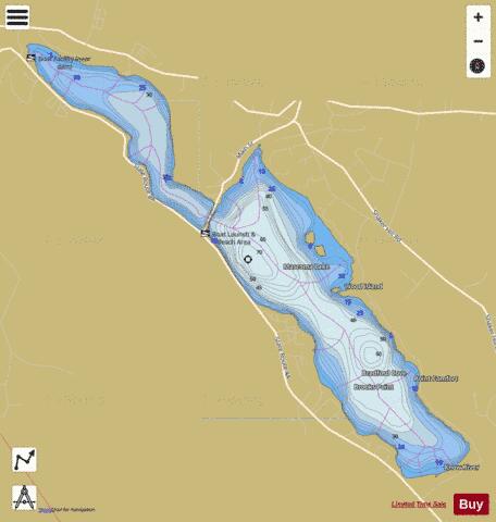
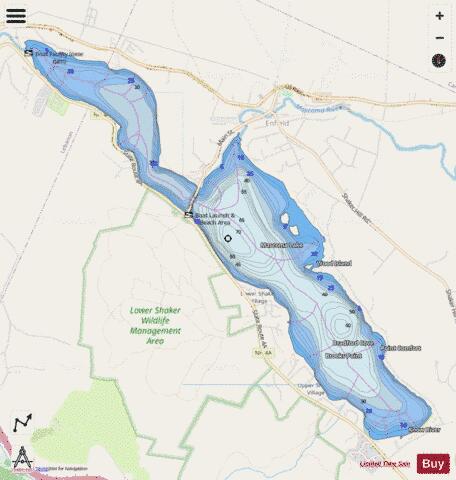
Mascoma Lake Fishing Map Stats | |
| Title | Mascoma Lake |
| Sailing Clubs in this Chart region | |
| Mascoma Sailing Club | |
| Scale | 1:3000 |
| Counties | Grafton |
| Nearby Cities | Enfield, Lebanon, Canaan, Grantham, Hanover, Wilder, White River Junction, Norwich, Springfield, Orange |
| Area * | 1155.23 acres |
| Shoreline * | 11.67 miles |
| Min Longitude | -72.18 |
| Min Latitude | 43.61 |
| Max Longitude | -72.12 |
| Max Latitude | 43.65 |
| Edition Label 1 | |
| Edition Label 2 | |
| Edition Label 3 | |
| Id | US_NH_00868293 |
| Country | US |
| Projection | Mercator |
| * some Stats may include nearby/connecting waterbodies | |
|