Little Sunapee Lake fishing map is available as part of iBoating : USA Marine & Fishing App(now supported on multiple platforms including Android, iPhone/iPad, MacBook, and Windows(tablet and phone)/PC based chartplotter.).
With our Lake Maps App, you get all the great marine chart app features like fishing spots, along with Little Sunapee Lake depth map. The fishing maps app include HD lake depth contours, along with advanced features found in Fish Finder / Gps Chart Plotter systems, turning your device into a Depth Finder. The Little Sunapee Lake Navigation App provides advanced features of a Marine Chartplotter including adjusting water level offset and custom depth shading. Fishing spots and depth contours layers are available in most Lake maps. Lake navigation features include advanced instrumentation to gather wind speed direction, water temperature, water depth, and accurate GPS with AIS receivers(using NMEA over TCP/UDP). Autopilot support can be enabled during ‘Goto WayPoint’ and ‘Route Assistance’.
Now i-Boating supports Fishing Points in Little Sunapee Lake.
Have more questions about the Nautical Chart App? Ask us.
Fishing Info for Little Sunapee Lake
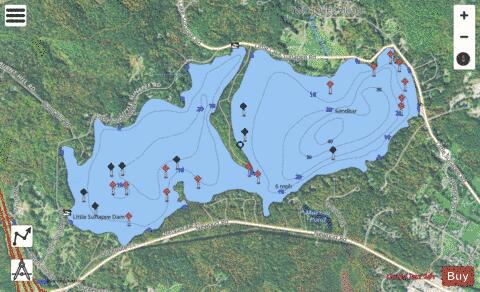
Little Sunapee Lake (or "Little Lake Sunapee", a frequent local usage) is a 486-acre (197 ha) water body located primarily in Merrimack County in central New Hampshire, United States, in the town of New London. A small portion of the lake crosses into neighboring Springfield in Sullivan County. The lake is sometimes referred to as "Twin Lakes" due to a long, narrow peninsula which nearly cuts the lake in half. Water flowing out of the lake passes through Goose Pond and Otter Pond before entering Lake Sunapee. Bucklin Beach is a Town of New London recreation area at the east end of the lake. The lake is classified as a warmwater fishery and contains rainbow trout, smallmouth bass, chain pickerel, and horned pout.
More on Wikipedia...Popular fish species in this lake include Brown bullhead, Chain pickerel, Rainbow trout and Smallmouth bass.
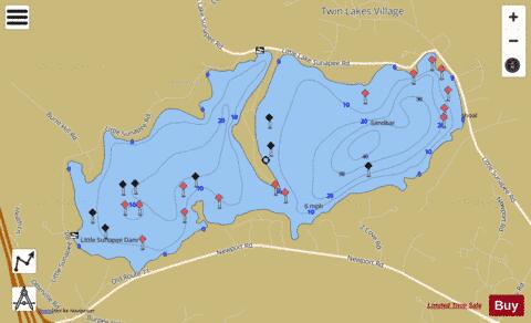
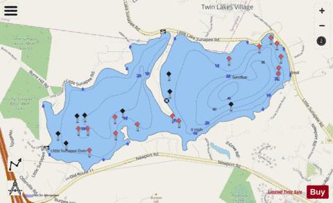
Little Sunapee Lake Fishing Map Stats | |
| Title | Little Sunapee Lake |
| Scale | 1:3000 |
| Counties | Merrimack, Sullivan |
| Nearby Cities | New London, Georges Mills, Blodgett Landing, Springfield, Sunapee, Wilmot, North Sutton, Newbury, Sutton, Grantham |
| Area * | 486.16 acres |
| Shoreline * | 6.68 miles |
| Min Longitude | -72.03 |
| Min Latitude | 43.43 |
| Max Longitude | -72.00 |
| Max Latitude | 43.44 |
| Edition Label 1 | |
| Edition Label 2 | |
| Edition Label 3 | |
| Id | US_NH_00868096 |
| Country | US |
| Projection | Mercator |
| * some Stats may include nearby/connecting waterbodies | |
|