Highland Lake fishing map is available as part of iBoating : USA Marine & Fishing App(now supported on multiple platforms including Android, iPhone/iPad, MacBook, and Windows(tablet and phone)/PC based chartplotter.).
With our Lake Maps App, you get all the great marine chart app features like fishing spots, along with Highland Lake depth map. The fishing maps app include HD lake depth contours, along with advanced features found in Fish Finder / Gps Chart Plotter systems, turning your device into a Depth Finder. The Highland Lake Navigation App provides advanced features of a Marine Chartplotter including adjusting water level offset and custom depth shading. Fishing spots and depth contours layers are available in most Lake maps. Lake navigation features include advanced instrumentation to gather wind speed direction, water temperature, water depth, and accurate GPS with AIS receivers(using NMEA over TCP/UDP). Autopilot support can be enabled during ‘Goto WayPoint’ and ‘Route Assistance’.
Now i-Boating supports Fishing Points in Highland Lake.
Have more questions about the Nautical Chart App? Ask us.
Fishing Info for Highland Lake
Highland Lake is a 697-acre (2.82 km2) water body located in Sullivan and Cheshire counties in southwestern New Hampshire, United States, in the towns of Washington and Stoddard. The lake has two outlets. The north outlet feeds Shedd Brook, while the south outlet flows through Island Pond to the North Branch of the Contoocook River. Water from the two outlets rejoins in the town of Hillsborough, approximately 8 miles (13 km) east of Highland Lake and one mile upstream from the Contoocook River. The northern end of the lake is only accessible by boat through a channel approximately 50 feet wide. The lake has been a popular site for recreational boating during the summer and snowmobiling during the winter since before the 1960s. Waterskiiers are a frequent sight, and sea planes are known to occasionally use the lake. Most of the lakeside real estate has seasonal and year-round residences situated on plots of land smaller than .25 acres. The Highland Lake Marina (the waterway's only such establishment) is located at the end of Shedd Hill Road. It is open during summer weekends, and offers boat storage, docking, and recreational merchandise. There is also a diner attached. The lake is classified as a warmwater fishery and is home to species such as black crappie, largemouth bass, smallmouth bass, chain pickerel, horned pout, and white perch. The land surrounding Pickerel Cove is owned and protected by the Society for the Protection of New Hampshire Forests.
More on Wikipedia...Popular fish species in this lake include Black crappie, Brown bullhead, Chain pickerel, Largemouth bass and Smallmouth bass.
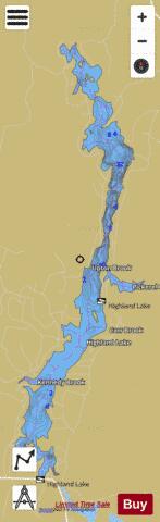
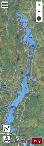
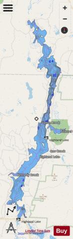
Highland Lake Fishing Map Stats | |
| Title | Highland Lake |
| Scale | 1:3000 |
| Counties | Cheshire, Sullivan |
| Nearby Cities | Stoddard, Washington, Nelson, Marlow, Harrisville, Sullivan, Lempster, Hancock, Antrim, Goshen |
| Area * | 696.57 acres |
| Shoreline * | 19.72 miles |
| Min Longitude | -72.10 |
| Min Latitude | 43.08 |
| Max Longitude | -72.07 |
| Max Latitude | 43.15 |
| Edition Label 1 | |
| Edition Label 2 | |
| Edition Label 3 | |
| Id | US_NH_00867486 |
| Country | US |
| Projection | Mercator |
| * some Stats may include nearby/connecting waterbodies | |
|